Livada de Bihor elevation
Livada de Bihor (Bihor, Comuna Nojorid), Romania elevation is 125 meters and Livada de Bihor elevation in feet is 410 ft above sea level [src 1]. Livada de Bihor is a populated place (feature code) with elevation that is 127 meters (417 ft) smaller than average city elevation in Romania.
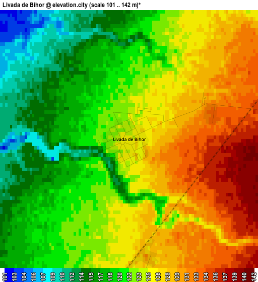
Below is the Elevation map of Livada de Bihor, which displays elevation range with different colors. Scale of the first map is from 101 to 142 m (331 to 466 ft) with average elevation of 122.9 meters (=403 ft) [note 1]
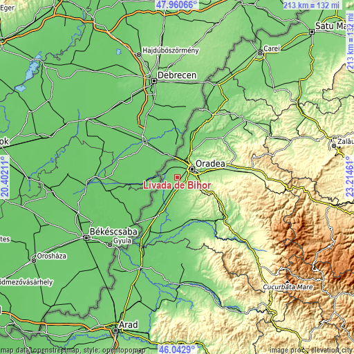
These maps also provides idea of topography and contour of this city, they are displayed at different zoom levels. More info about maps, scale and edge coordinates you can find below images.
| \ | Map #1 | Topo.Map |
| Scale [m] | 101..142 m | × |
| Scale [ft] | 331..466 ft | × |
| Average | 122.9 m = 403 ft | × |
| Width | 6.66 km = 4.1 mi | 213.2 km = 132.5 mi |
| Height | 6.66 km = 4.1 mi | 213.2 km = 132.5 mi |
| ↑Max Latitude | 47.040346° | 47.96066° |
| Latitude at center | 47.01039° | 47.01039° |
| ↓Min Latitude | 46.980417° | 46.0429° |
| ← Min Longitude | 21.764415° | 20.40211° |
| Longitude center | 21.80836° | 21.80836° |
| →Max Longitude | 21.852305° | 23.21461° |
Nearby cities:
Cities around Livada de Bihor sort by population:
• Oradea elevation 123 m
9.2 km,  64°
64°
• Cefa 101 m
11.9 km,  208°
208°
• Nojorid 145 m
6.4 km,  117°
117°
• Sântandrei 112 m
7.1 km,  28°
28°
• Sînmartin 148 m
12.6 km,  91°
91°
• Borş 103 m
11.8 km,  3°
3°
• Girișu de Criș 102 m
7 km,  329°
329°
• Sântion 106 m
9.8 km,  12°
12°
• Cordău 261 m
14.9 km, 116°
• Sânnicolau Român 101 m
9 km,  232°
232°
• Gepiu 108 m
9 km,  188°
188°
• Toboliu 98 m
7.6 km,  297°
297°
Multilingual:
 En español:
Livada de Bihor elevación 125 m.
 En France:
Livada de Bihor élévation 125 m.
 Auf Deutsch:
Livada de Bihor höhe über dem Meeresspiegel ist 125 m.

Sources and notes:
- [note 1] Map square and city borders are not equal. Map elevation data is calculated only from area inside that square.
- [src 1] Elevation data from geonames database provided with same terms of usage.
- [src 2] The elevation map of Livada de Bihor is generated using elevation data from NASA's 3 arcsec (90m) resolution SRTM data.
- [src 3] Base (background) map © OpenStreetMap contributors tiles are generated by Geofabrik and OpenTopoMap.
Copyright & License:
This Livada de Bihor Elevation Map is licensed under CC BY-SA. You may reuse any part from this page, if you give a proper credit by linking to this URL:
 More info on terms of use page.