Ceica elevation
Ceica (Bihor, Comuna Ceica), Romania elevation is 153 meters and Ceica elevation in feet is 502 ft above sea level [src 1]. Ceica is a seat of a second-order administrative division (feature code) with elevation that is 99 meters (325 ft) smaller than average city elevation in Romania.
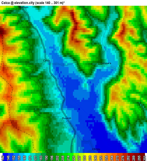
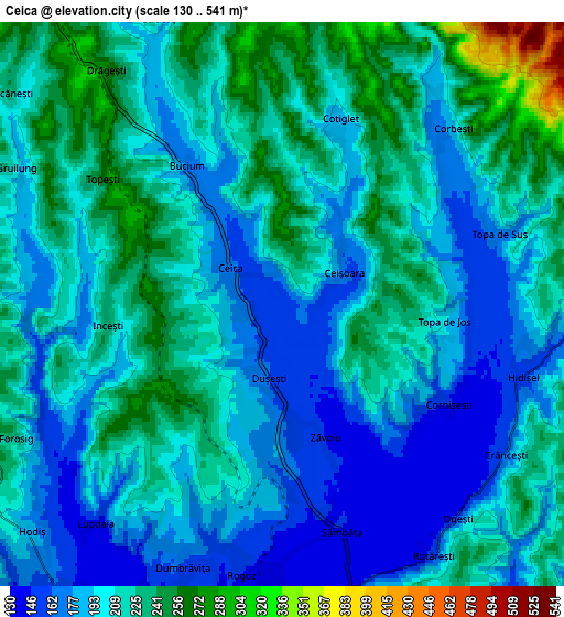
Below is the Elevation map of Ceica, which displays elevation range with different colors. Scale of the first map is from 140 to 301 m (459 to 988 ft) with average elevation of 200.3 meters (=657 ft) [note 1]
These maps also provides idea of topography and contour of this city, they are displayed at different zoom levels. More info about maps, scale and edge coordinates you can find below images.
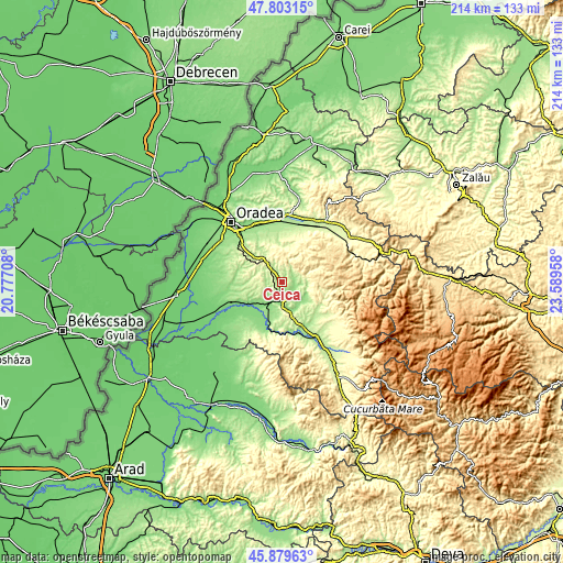
| \ | Map #1 | Map #2 | Topo.Map |
| Scale [m] | 140..301 m | 130..541 m | × |
| Scale [ft] | 459..988 ft | 427..1775 ft | × |
| Average | 200.3 m = 657 ft | 205.3 m = 674 ft | × |
| Width | 6.68 km = 4.2 mi | 13.37 km = 8.3 mi | 213.9 km = 132.9 mi |
| Height | 6.68 km = 4.2 mi | 13.37 km = 8.3 mi | 213.9 km = 132.9 mi |
| ↑Max Latitude | 46.880046° | 46.910076° | 47.80315° |
| Latitude at center | 46.85° | 46.85° | 46.85° |
| ↓Min Latitude | 46.819937° | 46.789857° | 45.87963° |
| ← Min Longitude | 22.139385° | 22.095439° | 20.77708° |
| Longitude center | 22.18333° | 22.18333° | 22.18333° |
| →Max Longitude | 22.227275° | 22.271221° | 23.58958° |
Nearby cities:
Cities around Ceica sort by population:
• Dobreşti elevation 273 m
8.9 km,  90°
90°
• Holod 130 m
8.3 km,  207°
207°
• Pomezeu 145 m
10.6 km,  134°
134°
• Lăzăreni 294 m
9.1 km,  281°
281°
• Câmpani de Pomezeu 182 m
11.6 km,  118°
118°
• Drăgeşti 217 m
5.3 km,  314°
314°
• Copăcel 209 m
14.9 km,  355°
355°
• Răbăgani 144 m
11.8 km,  161°
161°
• Căpâlna 132 m
14.4 km, 206°
• Tășad 308 m
10.7 km,  335°
335°
• Vintere 159 m
9.4 km,  197°
197°
• Sâmbăta 140 m
5.6 km, 163°
Multilingual:
 En español:
Ceica elevación 153 m.
 En France:
Ceica élévation 153 m.


Sources and notes:
- [note 1] Map square and city borders are not equal. Map elevation data is calculated only from area inside that square.
- [src 1] Elevation data from geonames database provided with same terms of usage.
- [src 2] The elevation map of Ceica is generated using elevation data from NASA's 3 arcsec (90m) resolution SRTM data.
- [src 3] Base (background) map © OpenStreetMap contributors tiles are generated by Geofabrik and OpenTopoMap.
Copyright & License:
This Ceica Elevation Map is licensed under CC BY-SA. You may reuse any part from this page, if you give a proper credit by linking to this URL:
 More info on terms of use page.