Luncșoara elevation
Luncșoara (Bihor, Comuna Auşeu), Romania elevation is 303 meters and Luncșoara elevation in feet is 994 ft above sea level [src 1]. Luncșoara is a populated place (feature code) with elevation that is 51 meters (167 ft) bigger than average city elevation in Romania.
Below is the Elevation map of Luncșoara, which displays elevation range with different colors. Scale of the first map is from 251 to 718 m (823 to 2356 ft) with average elevation of 371.1 meters (=1218 ft) [note 1]
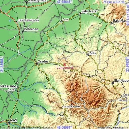
These maps also provides idea of topography and contour of this city, they are displayed at different zoom levels. More info about maps, scale and edge coordinates you can find below images.
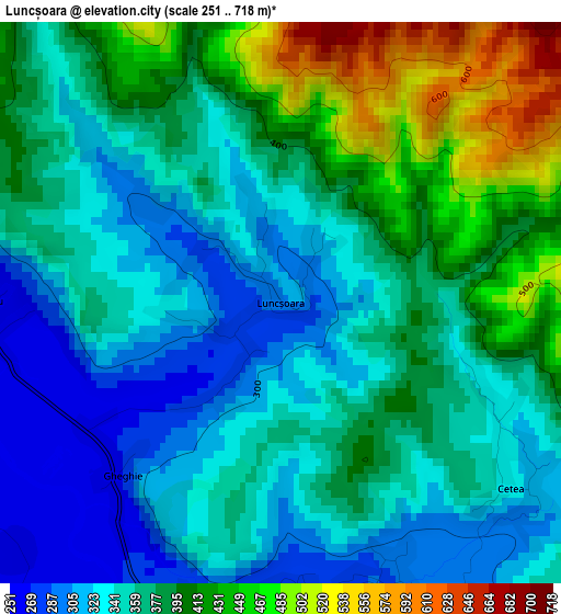
| \ | Map #1 | Topo.Map |
| Scale [m] | 251..718 m | × |
| Scale [ft] | 823..2356 ft | × |
| Average | 371.1 m = 1218 ft | × |
| Width | 6.66 km = 4.1 mi | 213.1 km = 132.4 mi |
| Height | 6.66 km = 4.1 mi | 213.1 km = 132.4 mi |
| ↑Max Latitude | 47.066572° | 47.98643° |
| Latitude at center | 47.03663° | 47.03663° |
| ↓Min Latitude | 47.006672° | 46.06961° |
| ← Min Longitude | 22.498185° | 21.13588° |
| Longitude center | 22.54213° | 22.54213° |
| →Max Longitude | 22.586075° | 23.94838° |
Nearby cities:
Cities around Luncșoara sort by population:
• Aleşd elevation 255 m
10.1 km,  289°
289°
• Bratca 381 m
12.8 km,  153°
153°
• Vadu Crişului 277 m
6.2 km,  198°
198°
• Borod 379 m
9.1 km,  130°
130°
• Aştileu 229 m
12 km,  268°
268°
• Şuncuiuş 507 m
11.5 km,  183°
183°
• Auşeu 252 m
3.2 km,  263°
263°
• Măgeşti 252 m
7.3 km,  252°
252°
• Beznea 366 m
10.4 km, 145°
• Peștiș 244 m
10.6 km, 292°
• Bălnaca 379 m
10.6 km,  167°
167°
• Groși 248 m
4.8 km,  281°
281°
Multilingual:
 En español:
Luncșoara elevación 303 m.
 En France:
Luncșoara élévation 303 m.
 Auf Deutsch:
Luncșoara höhe über dem Meeresspiegel ist 303 m.

Sources and notes:
- [note 1] Map square and city borders are not equal. Map elevation data is calculated only from area inside that square.
- [src 1] Elevation data from geonames database provided with same terms of usage.
- [src 2] The elevation map of Luncșoara is generated using elevation data from NASA's 3 arcsec (90m) resolution SRTM data.
- [src 3] Base (background) map © OpenStreetMap contributors tiles are generated by Geofabrik and OpenTopoMap.
Copyright & License:
This Luncșoara Elevation Map is licensed under CC BY-SA. You may reuse any part from this page, if you give a proper credit by linking to this URL:
 More info on terms of use page.