Arouca elevation
Arouca (Aveiro), Portugal elevation is 313 meters and Arouca elevation in feet is 1027 ft above sea level [src 1]. Arouca is a seat of a second-order administrative division (feature code) with elevation that is 145 meters (476 ft) bigger than average city elevation in Portugal.
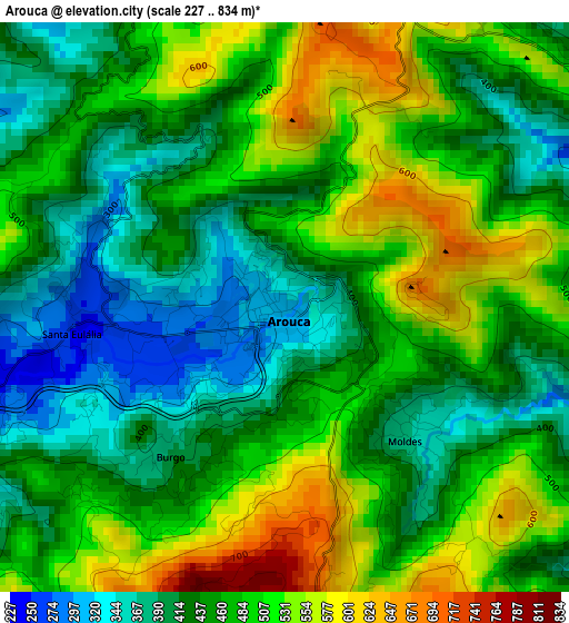
Below is the Elevation map of Arouca, which displays elevation range with different colors. Scale of the first map is from 227 to 834 m (745 to 2736 ft) with average elevation of 466.5 meters (=1531 ft) [note 1]
These maps also provides idea of topography and contour of this city, they are displayed at different zoom levels. More info about maps, scale and edge coordinates you can find below images.
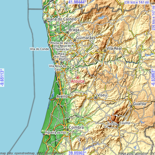
| \ | Map #1 | Topo.Map |
| Scale [m] | 227..834 m | × |
| Scale [ft] | 745..2736 ft | × |
| Average | 466.5 m = 1531 ft | × |
| Width | 7.38 km = 4.6 mi | 236.3 km = 146.8 mi |
| Height | 7.38 km = 4.6 mi | 236.3 km = 146.8 mi |
| ↑Max Latitude | 40.963763° | 41.98444° |
| Latitude at center | 40.93057° | 40.93057° |
| ↓Min Latitude | 40.897361° | 39.85962° |
| ← Min Longitude | -8.288825° | -9.65113° |
| Longitude center | -8.24488° | -8.24488° |
| →Max Longitude | -8.200935° | -6.83863° |
Nearby cities:
Cities around Arouca sort by population:
• São João da Madeira elevation 204 m
20.9 km,  260°
260°
• Moreira 75 m
18.5 km,  318°
318°
• Melres 44 m
20.3 km, 319°
• Alpendurada 216 m
17.7 km,  359°
359°
• Vale de Cambra 240 m
15.4 km,  234°
234°
• São Roque 208 m
20.1 km,  251°
251°
• Macieira de Cambra 362 m
13.4 km, 233°
• Milheirós de Poiares 246 m
18.8 km,  266°
266°
• Vila Chã 216 m
19.9 km, 249°
• Rio Mau 32 m
17.4 km, 323°
• Cinfães 404 m
20.4 km,  39°
39°
• Castelo de Paiva 31 m
14.8 km,  353°
353°
Multilingual:
 En español:
Arouca elevación 313 m.
 En France:
Arouca élévation 313 m.


Sources and notes:
- [note 1] Map square and city borders are not equal. Map elevation data is calculated only from area inside that square.
- [src 1] Elevation data from geonames database provided with same terms of usage.
- [src 2] The elevation map of Arouca is generated using elevation data from NASA's 3 arcsec (90m) resolution SRTM data.
- [src 3] Base (background) map © OpenStreetMap contributors tiles are generated by Geofabrik and OpenTopoMap.
Copyright & License:
This Arouca Elevation Map is licensed under CC BY-SA. You may reuse any part from this page, if you give a proper credit by linking to this URL:
 More info on terms of use page.