São Roque elevation
São Roque (Aveiro, Oliveira de Azeméis), Portugal elevation is 208 meters and São Roque elevation in feet is 682 ft above sea level [src 1]. São Roque is a populated place (feature code) with elevation that is 40 meters (131 ft) bigger than average city elevation in Portugal.
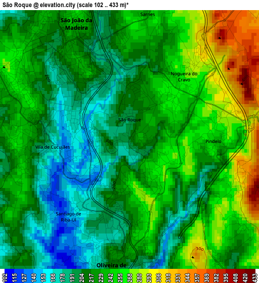
Below is the Elevation map of São Roque, which displays elevation range with different colors. Scale of the first map is from 102 to 433 m (335 to 1421 ft) with average elevation of 227.5 meters (=746 ft) [note 1]
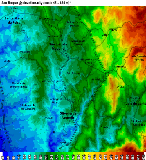
These maps also provides idea of topography and contour of this city, they are displayed at different zoom levels. More info about maps, scale and edge coordinates you can find below images.
| \ | Map #1 | Map #2 | Topo.Map |
| Scale [m] | 102..433 m | 45..634 m | × |
| Scale [ft] | 335..1421 ft | 148..2080 ft | × |
| Average | 227.5 m = 746 ft | 241.3 m = 792 ft | × |
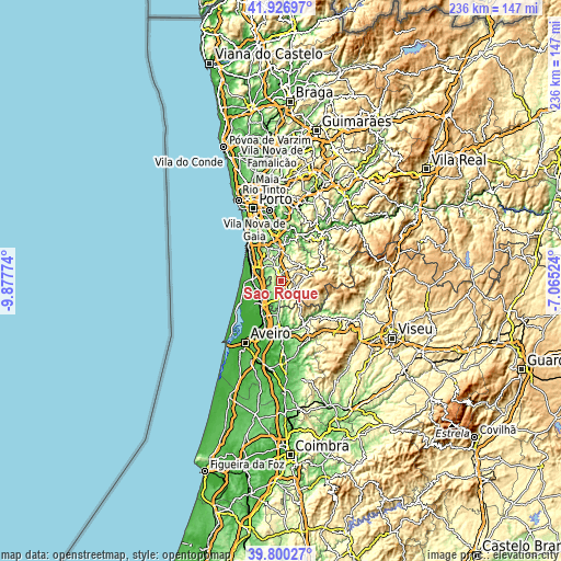
| Width | 7.39 km = 4.6 mi | 14.78 km = 9.2 mi | 236.5 km = 147 mi |
| Height | 7.39 km = 4.6 mi | 14.78 km = 9.2 mi | 236.5 km = 147 mi |
| ↑Max Latitude | 40.905382° | 40.938587° | 41.92697° |
| Latitude at center | 40.87216° | 40.87216° | 40.87216° |
| ↓Min Latitude | 40.838921° | 40.805666° | 39.80027° |
| ← Min Longitude | -8.515435° | -8.559381° | -9.87774° |
| Longitude center | -8.47149° | -8.47149° | -8.47149° |
| →Max Longitude | -8.427545° | -8.383599° | -7.06524° |
Nearby cities:
Cities around São Roque sort by population:
• São João da Madeira elevation 204 m
3.5 km,  333°
333°
• Feira 122 m
8.4 km,  314°
314°
• Oliveira de Azemeis 221 m
3.5 km,  185°
185°
• Cucujães 236 m
3 km,  274°
274°
• Vale de Cambra 240 m
7 km,  110°
110°
• Válega 41 m
10 km,  246°
246°
• Arrifana 271 m
5.3 km,  336°
336°
• Macieira de Cambra 362 m
8.4 km,  99°
99°
• Milheirós de Poiares 246 m
5.5 km,  3°
3°
• Vila Chã 216 m
0.7 km,  146°
146°
• Mosteirô 226 m
5.9 km,  299°
299°
• Sanfins 167 m
7.9 km,  324°
324°
Multilingual:
 En español:
São Roque elevación 208 m.
 En France:
São Roque élévation 208 m.
 Auf Deutsch:
São Roque höhe über dem Meeresspiegel ist 208 m.

Sources and notes:
- [note 1] Map square and city borders are not equal. Map elevation data is calculated only from area inside that square.
- [src 1] Elevation data from geonames database provided with same terms of usage.
- [src 2] The elevation map of São Roque is generated using elevation data from NASA's 3 arcsec (90m) resolution SRTM data.
- [src 3] Base (background) map © OpenStreetMap contributors tiles are generated by Geofabrik and OpenTopoMap.
Copyright & License:
This São Roque Elevation Map is licensed under CC BY-SA. You may reuse any part from this page, if you give a proper credit by linking to this URL:
 More info on terms of use page.