Feira elevation
Feira (Aveiro, Santa Maria da Feira), Portugal elevation is 122 meters and Feira elevation in feet is 400 ft above sea level [src 1]. Feira is a seat of a second-order administrative division (feature code) with elevation that is 46 meters (151 ft) smaller than average city elevation in Portugal.
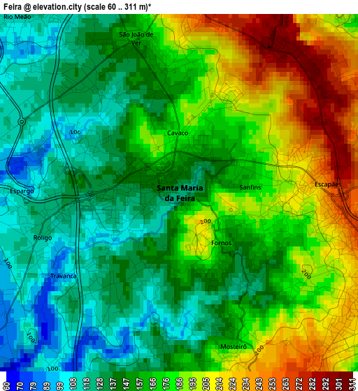
Below is the Elevation map of Feira, which displays elevation range with different colors. Scale of the first map is from 60 to 311 m (197 to 1020 ft) with average elevation of 163.6 meters (=537 ft) [note 1]
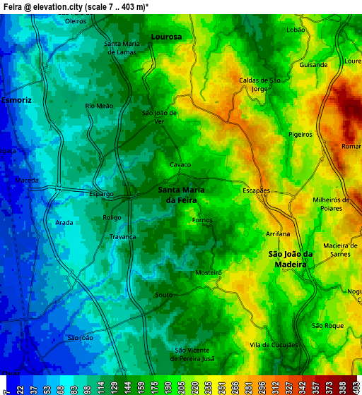
These maps also provides idea of topography and contour of this city, they are displayed at different zoom levels. More info about maps, scale and edge coordinates you can find below images.
| \ | Map #1 | Map #2 | Topo.Map |
| Scale [m] | 60..311 m | 7..403 m | × |
| Scale [ft] | 197..1020 ft | 23..1322 ft | × |
| Average | 163.6 m = 537 ft | 152.6 m = 501 ft | × |
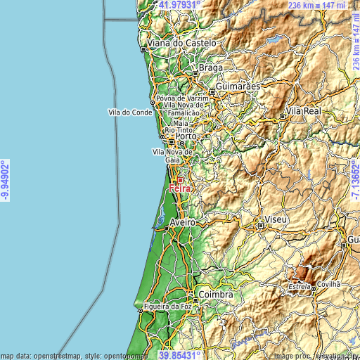
| Width | 7.38 km = 4.6 mi | 14.77 km = 9.2 mi | 236.3 km = 146.8 mi |
| Height | 7.38 km = 4.6 mi | 14.77 km = 9.2 mi | 236.3 km = 146.8 mi |
| ↑Max Latitude | 40.958545° | 40.991724° | 41.97931° |
| Latitude at center | 40.92535° | 40.92535° | 40.92535° |
| ↓Min Latitude | 40.892138° | 40.85891° | 39.85431° |
| ← Min Longitude | -8.586715° | -8.630661° | -9.94902° |
| Longitude center | -8.54277° | -8.54277° | -8.54277° |
| →Max Longitude | -8.498825° | -8.454879° | -7.13652° |
Nearby cities:
Cities around Feira sort by population:
• São João da Madeira elevation 204 m
5.2 km,  121°
121°
• Cucujães 236 m
6.4 km,  152°
152°
• Lourosa 159 m
6.6 km,  353°
353°
• São João de Ver 170 m
3.4 km, 348°
• Arrifana 271 m
4 km,  105°
105°
• Rio Meão 117 m
4.7 km,  320°
320°
• Paços de Brandão 114 m
6.5 km,  328°
328°
• Milheirós de Poiares 246 m
6.3 km,  93°
93°
• Cortegaça 53 m
7.1 km,  291°
291°
• Mosteirô 226 m
3.1 km,  163°
163°
• Sanfins 167 m
1.5 km,  71°
71°
• Espargo 119 m
2.7 km,  268°
268°
Multilingual:
 En español:
Feira elevación 122 m.
 En France:
Feira élévation 122 m.


Sources and notes:
- [note 1] Map square and city borders are not equal. Map elevation data is calculated only from area inside that square.
- [src 1] Elevation data from geonames database provided with same terms of usage.
- [src 2] The elevation map of Feira is generated using elevation data from NASA's 3 arcsec (90m) resolution SRTM data.
- [src 3] Base (background) map © OpenStreetMap contributors tiles are generated by Geofabrik and OpenTopoMap.
Copyright & License:
This Feira Elevation Map is licensed under CC BY-SA. You may reuse any part from this page, if you give a proper credit by linking to this URL:
 More info on terms of use page.