Alpendurada elevation
Alpendurada (Porto, Marco de Canaveses), Portugal elevation is 216 meters and Alpendurada elevation in feet is 709 ft above sea level [src 1]. Alpendurada is a populated place (feature code) with elevation that is 48 meters (157 ft) bigger than average city elevation in Portugal.
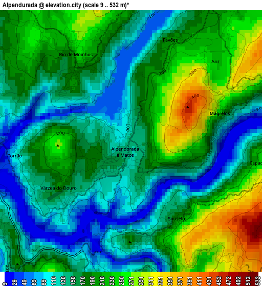
Below is the Elevation map of Alpendurada, which displays elevation range with different colors. Scale of the first map is from 9 to 532 m (30 to 1745 ft) with average elevation of 177.6 meters (=583 ft) [note 1]
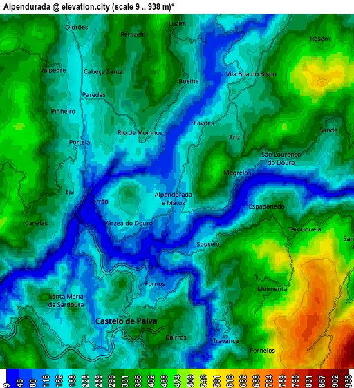
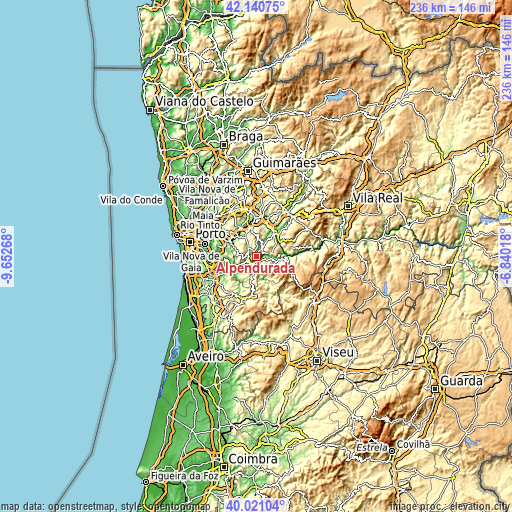
These maps also provides idea of topography and contour of this city, they are displayed at different zoom levels. More info about maps, scale and edge coordinates you can find below images.
| \ | Map #1 | Map #2 | Topo.Map |
| Scale [m] | 9..532 m | 9..938 m | × |
| Scale [ft] | 30..1745 ft | 30..3077 ft | × |
| Average | 177.6 m = 583 ft | 272.6 m = 894 ft | × |
| Width | 7.37 km = 4.6 mi | 14.73 km = 9.2 mi | 235.7 km = 146.5 mi |
| Height | 7.37 km = 4.6 mi | 14.73 km = 9.2 mi | 235.7 km = 146.5 mi |
| ↑Max Latitude | 41.122553° | 41.155648° | 42.14075° |
| Latitude at center | 41.08944° | 41.08944° | 41.08944° |
| ↓Min Latitude | 41.056311° | 41.023165° | 40.02104° |
| ← Min Longitude | -8.290375° | -8.334321° | -9.65268° |
| Longitude center | -8.24643° | -8.24643° | -8.24643° |
| →Max Longitude | -8.202485° | -8.158539° | -6.84018° |
Nearby cities:
Cities around Alpendurada sort by population:
• Paredes elevation 179 m
14.7 km,  330°
330°
• Perafita 437 m
10.4 km,  356°
356°
• Moreira 75 m
12.5 km,  252°
252°
• Melres 44 m
13.1 km,  260°
260°
• Madalena 165 m
15.9 km, 332°
• Marco de Canavezes 206 m
13.3 km,  37°
37°
• Castelões de Cepeda 154 m
14.6 km, 329°
• Penafiel 286 m
13.6 km,  347°
347°
• Recarei 85 m
15.6 km,  297°
297°
• Rio Mau 32 m
10.9 km, 249°
• Cinfães 404 m
13.3 km,  98°
98°
• Castelo de Paiva 31 m
3.3 km,  207°
207°
Multilingual:
 En español:
Alpendurada elevación 216 m.
 En France:
Alpendurada élévation 216 m.
 Auf Deutsch:
Alpendurada höhe über dem Meeresspiegel ist 216 m.

Sources and notes:
- [note 1] Map square and city borders are not equal. Map elevation data is calculated only from area inside that square.
- [src 1] Elevation data from geonames database provided with same terms of usage.
- [src 2] The elevation map of Alpendurada is generated using elevation data from NASA's 3 arcsec (90m) resolution SRTM data.
- [src 3] Base (background) map © OpenStreetMap contributors tiles are generated by Geofabrik and OpenTopoMap.
Copyright & License:
This Alpendurada Elevation Map is licensed under CC BY-SA. You may reuse any part from this page, if you give a proper credit by linking to this URL:
 More info on terms of use page.