Proença-a-Nova elevation
Proença-a-Nova (Castelo Branco, Proença-A-Nova), Portugal elevation is 464 meters and Proença-a-Nova elevation in feet is 1522 ft above sea level [src 1]. Proença-a-Nova is a seat of a second-order administrative division (feature code) with elevation that is 296 meters (971 ft) bigger than average city elevation in Portugal.
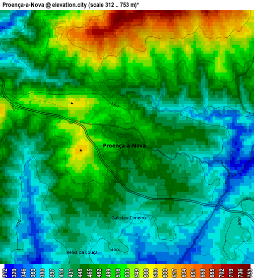
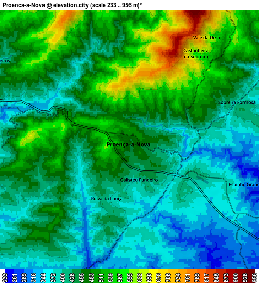
Below is the Elevation map of Proença-a-Nova, which displays elevation range with different colors. Scale of the first map is from 312 to 753 m (1024 to 2470 ft) with average elevation of 463.3 meters (=1520 ft) [note 1]
These maps also provides idea of topography and contour of this city, they are displayed at different zoom levels. More info about maps, scale and edge coordinates you can find below images.
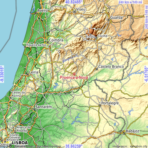
| \ | Map #1 | Map #2 | Topo.Map |
| Scale [m] | 312..753 m | 233..956 m | × |
| Scale [ft] | 1024..2470 ft | 764..3136 ft | × |
| Average | 463.3 m = 1520 ft | 452.9 m = 1486 ft | × |
| Width | 7.51 km = 4.7 mi | 15.03 km = 9.3 mi | 240.4 km = 149.4 mi |
| Height | 7.51 km = 4.7 mi | 15.03 km = 9.3 mi | 240.4 km = 149.4 mi |
| ↑Max Latitude | 39.785978° | 39.819739° | 40.82485° |
| Latitude at center | 39.7522° | 39.7522° | 39.7522° |
| ↓Min Latitude | 39.718406° | 39.684595° | 38.66259° |
| ← Min Longitude | -7.967845° | -8.011791° | -9.33015° |
| Longitude center | -7.9239° | -7.9239° | -7.9239° |
| →Max Longitude | -7.879955° | -7.836009° | -6.51765° |
Nearby cities:
Cities around Proença-a-Nova sort by population:
• Oleiros elevation 510 m
18.6 km,  2°
2°
• Sertã 262 m
15.7 km,  290°
290°
• Gavião 284 m
32 km,  181°
181°
• Sardoal 197 m
31.6 km,  220°
220°
• Pedrógão Grande 400 m
26.5 km,  314°
314°
• Vila Velha de Ródão 183 m
23.7 km,  116°
116°
• Vila de Rei 444 m
20.8 km,  245°
245°
• Atalaia 261 m
33.3 km,  172°
172°
• Pampilhosa da Serra 398 m
32.8 km,  355°
355°
• Figueiró dos Vinhos 464 m
34.4 km,  299°
299°
• Ferreira do Zêzere 355 m
32.1 km,  258°
258°
• Mação 315 m
22.7 km,  195°
195°
Multilingual:
 En español:
Proença-a-Nova elevación 464 m.
 En France:
Proença-a-Nova élévation 464 m.
 Auf Deutsch:
Proença-a-Nova höhe über dem Meeresspiegel ist 464 m.

Sources and notes:
- [note 1] Map square and city borders are not equal. Map elevation data is calculated only from area inside that square.
- [src 1] Elevation data from geonames database provided with same terms of usage.
- [src 2] The elevation map of Proença-a-Nova is generated using elevation data from NASA's 3 arcsec (90m) resolution SRTM data.
- [src 3] Base (background) map © OpenStreetMap contributors tiles are generated by Geofabrik and OpenTopoMap.
Copyright & License:
This Proença-a-Nova Elevation Map is licensed under CC BY-SA. You may reuse any part from this page, if you give a proper credit by linking to this URL:
 More info on terms of use page.