Vila de Rei elevation
Vila de Rei (Castelo Branco), Portugal elevation is 444 meters and Vila de Rei elevation in feet is 1457 ft above sea level [src 1]. Vila de Rei is a seat of a second-order administrative division (feature code) with elevation that is 276 meters (906 ft) bigger than average city elevation in Portugal.
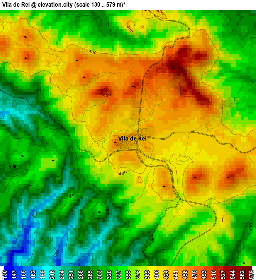
Below is the Elevation map of Vila de Rei, which displays elevation range with different colors. Scale of the first map is from 130 to 579 m (427 to 1900 ft) with average elevation of 360.9 meters (=1184 ft) [note 1]
These maps also provides idea of topography and contour of this city, they are displayed at different zoom levels. More info about maps, scale and edge coordinates you can find below images.
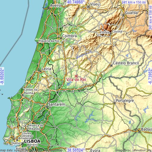
| \ | Map #1 | Topo.Map |
| Scale [m] | 130..579 m | × |
| Scale [ft] | 427..1900 ft | × |
| Average | 360.9 m = 1184 ft | × |
| Width | 7.52 km = 4.7 mi | 240.7 km = 149.6 mi |
| Height | 7.52 km = 4.7 mi | 240.7 km = 149.6 mi |
| ↑Max Latitude | 39.709855° | 40.74988° |
| Latitude at center | 39.67604° | 39.67604° |
| ↓Min Latitude | 39.642208° | 38.58524° |
| ← Min Longitude | -8.189715° | -9.55202° |
| Longitude center | -8.14577° | -8.14577° |
| →Max Longitude | -8.101825° | -6.73952° |
Nearby cities:
Cities around Vila de Rei sort by population:
• Tomar elevation 55 m
24 km,  249°
249°
• Abrantes 133 m
23.7 km,  191°
191°
• Sertã 262 m
14.6 km,  16°
16°
• Proença-a-Nova 464 m
20.8 km,  65°
65°
• Sardoal 197 m
15.8 km,  184°
184°
• Alferrarede 66 m
21.5 km, 184°
• Pego 104 m
23.9 km, 180°
• Montalvinho 68 m
25.2 km,  211°
211°
• Montalvo 68 m
25.2 km, 211°
• Alvaiázere 311 m
25.8 km,  309°
309°
• Mação 315 m
18.6 km,  135°
135°
• Ferreira do Zêzere 355 m
12.7 km,  279°
279°
Multilingual:
 En español:
Vila de Rei elevación 444 m.
 En France:
Vila de Rei élévation 444 m.
 Auf Deutsch:
Vila de Rei höhe über dem Meeresspiegel ist 444 m.

Sources and notes:
- [note 1] Map square and city borders are not equal. Map elevation data is calculated only from area inside that square.
- [src 1] Elevation data from geonames database provided with same terms of usage.
- [src 2] The elevation map of Vila de Rei is generated using elevation data from NASA's 3 arcsec (90m) resolution SRTM data.
- [src 3] Base (background) map © OpenStreetMap contributors tiles are generated by Geofabrik and OpenTopoMap.
Copyright & License:
This Vila de Rei Elevation Map is licensed under CC BY-SA. You may reuse any part from this page, if you give a proper credit by linking to this URL:
 More info on terms of use page.