Tomar elevation
Tomar (Santarém), Portugal elevation is 55 meters and Tomar elevation in feet is 180 ft above sea level [src 1]. Tomar is a seat of a second-order administrative division (feature code) with elevation that is 113 meters (371 ft) smaller than average city elevation in Portugal.
Below is the Elevation map of Tomar, which displays elevation range with different colors. Scale of the first map is from 40 to 214 m (131 to 702 ft) with average elevation of 99.8 meters (=327 ft) [note 1]
These maps also provides idea of topography and contour of this city, they are displayed at different zoom levels. More info about maps, scale and edge coordinates you can find below images.
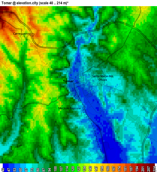
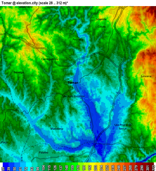
| \ | Map #1 | Map #2 | Topo.Map |
| Scale [m] | 40..214 m | 28..312 m | × |
| Scale [ft] | 131..702 ft | 92..1024 ft | × |
| Average | 99.8 m = 327 ft | 124.1 m = 407 ft | × |
| Width | 7.53 km = 4.7 mi | 15.06 km = 9.4 mi | 240.9 km = 149.7 mi |
| Height | 7.53 km = 4.7 mi | 15.06 km = 9.4 mi | 240.9 km = 149.7 mi |
| ↑Max Latitude | 39.635841° | 39.669676° | 40.677° |
| Latitude at center | 39.60199° | 39.60199° | 39.60199° |
| ↓Min Latitude | 39.568122° | 39.534238° | 38.51003° |
| ← Min Longitude | -8.453185° | -8.497131° | -9.81549° |
| Longitude center | -8.40924° | -8.40924° | -8.40924° |
| →Max Longitude | -8.365295° | -8.321349° | -7.00299° |
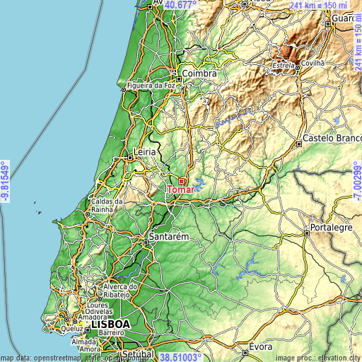
Nearby cities:
Cities around Tomar sort by population:
• Entroncamento elevation 34 m
15.8 km,  198°
198°
• Torres Novas 61 m
18.1 km,  219°
219°
• Ourém 315 m
16.3 km,  285°
285°
• Vila Nova da Barquinha 91 m
15.9 km,  188°
188°
• Madalena 112 m
4.7 km, 223°
• Paialvo 98 m
6.6 km,  230°
230°
• Santa Margarida da Coutada 125 m
18.7 km,  154°
154°
• Praia do Ribatejo 45 m
15.9 km,  161°
161°
• Montalvinho 68 m
16.2 km,  144°
144°
• Montalvo 68 m
16.2 km, 144°
• Constância 37 m
15.1 km, 155°
• Ferreira do Zêzere 355 m
14.3 km,  44°
44°
Multilingual:
 En español:
Tomar elevación 55 m.
 En France:
Tomar élévation 55 m.


Sources and notes:
- [note 1] Map square and city borders are not equal. Map elevation data is calculated only from area inside that square.
- [src 1] Elevation data from geonames database provided with same terms of usage.
- [src 2] The elevation map of Tomar is generated using elevation data from NASA's 3 arcsec (90m) resolution SRTM data.
- [src 3] Base (background) map © OpenStreetMap contributors tiles are generated by Geofabrik and OpenTopoMap.
Copyright & License:
This Tomar Elevation Map is licensed under CC BY-SA. You may reuse any part from this page, if you give a proper credit by linking to this URL:
 More info on terms of use page.