Praia do Ribatejo elevation
Praia do Ribatejo (Santarém, Vila Nova da Barquinha), Portugal elevation is 45 meters and Praia do Ribatejo elevation in feet is 148 ft above sea level [src 1]. Praia do Ribatejo is a populated place (feature code) with elevation that is 123 meters (404 ft) smaller than average city elevation in Portugal.
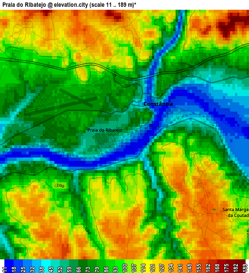
Below is the Elevation map of Praia do Ribatejo, which displays elevation range with different colors. Scale of the first map is from 11 to 189 m (36 to 620 ft) with average elevation of 90.4 meters (=297 ft) [note 1]
These maps also provides idea of topography and contour of this city, they are displayed at different zoom levels. More info about maps, scale and edge coordinates you can find below images.
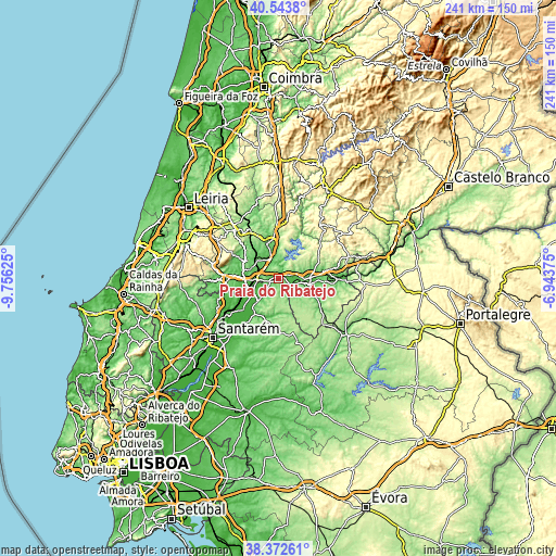
| \ | Map #1 | Topo.Map |
| Scale [m] | 11..189 m | × |
| Scale [ft] | 36..620 ft | × |
| Average | 90.4 m = 297 ft | × |
| Width | 7.54 km = 4.7 mi | 241.4 km = 150 mi |
| Height | 7.54 km = 4.7 mi | 241.4 km = 150 mi |
| ↑Max Latitude | 39.500587° | 40.5438° |
| Latitude at center | 39.46667° | 39.46667° |
| ↓Min Latitude | 39.432736° | 38.37261° |
| ← Min Longitude | -8.393945° | -9.75625° |
| Longitude center | -8.35° | -8.35° |
| →Max Longitude | -8.306055° | -6.94375° |
Nearby cities:
Cities around Praia do Ribatejo sort by population:
• Entroncamento elevation 34 m
10 km,  270°
270°
• Abrantes 133 m
12.9 km,  90°
90°
• Vila Nova da Barquinha 91 m
7.4 km,  264°
264°
• Riachos 42 m
14.3 km, 260°
• São Miguel de Rio Torto 143 m
12 km,  107°
107°
• Golegã 25 m
13.6 km,  239°
239°
• Tramagal 84 m
8.8 km,  102°
102°
• Santa Margarida da Coutada 125 m
3.4 km,  122°
122°
• Montalvinho 68 m
4.7 km,  66°
66°
• Montalvo 68 m
4.7 km, 66°
• Pinheiro Grande 46 m
11 km,  221°
221°
• Constância 37 m
1.7 km,  43°
43°
Multilingual:
 En español:
Praia do Ribatejo elevación 45 m.
 En France:
Praia do Ribatejo élévation 45 m.
 Auf Deutsch:
Praia do Ribatejo höhe über dem Meeresspiegel ist 45 m.

Sources and notes:
- [note 1] Map square and city borders are not equal. Map elevation data is calculated only from area inside that square.
- [src 1] Elevation data from geonames database provided with same terms of usage.
- [src 2] The elevation map of Praia do Ribatejo is generated using elevation data from NASA's 3 arcsec (90m) resolution SRTM data.
- [src 3] Base (background) map © OpenStreetMap contributors tiles are generated by Geofabrik and OpenTopoMap.
Copyright & License:
This Praia do Ribatejo Elevation Map is licensed under CC BY-SA. You may reuse any part from this page, if you give a proper credit by linking to this URL:
 More info on terms of use page.