Abrantes elevation
Abrantes (Santarém), Portugal elevation is 133 meters and Abrantes elevation in feet is 436 ft above sea level [src 1]. Abrantes is a seat of a second-order administrative division (feature code) with elevation that is 35 meters (115 ft) smaller than average city elevation in Portugal.
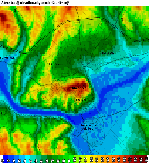
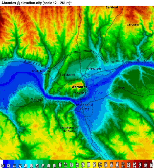
Below is the Elevation map of Abrantes, which displays elevation range with different colors. Scale of the first map is from 12 to 194 m (39 to 636 ft) with average elevation of 76.8 meters (=252 ft) [note 1]
These maps also provides idea of topography and contour of this city, they are displayed at different zoom levels. More info about maps, scale and edge coordinates you can find below images.
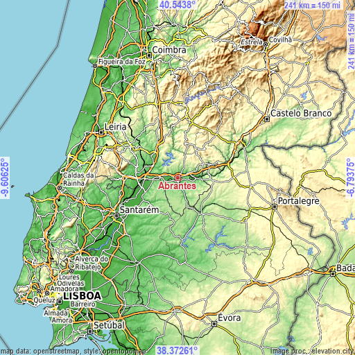
| \ | Map #1 | Map #2 | Topo.Map |
| Scale [m] | 12..194 m | 12..261 m | × |
| Scale [ft] | 39..636 ft | 39..856 ft | × |
| Average | 76.8 m = 252 ft | 111.8 m = 367 ft | × |
| Width | 7.54 km = 4.7 mi | 15.09 km = 9.4 mi | 241.4 km = 150 mi |
| Height | 7.54 km = 4.7 mi | 15.09 km = 9.4 mi | 241.4 km = 150 mi |
| ↑Max Latitude | 39.500587° | 39.534488° | 40.5438° |
| Latitude at center | 39.46667° | 39.46667° | 39.46667° |
| ↓Min Latitude | 39.432736° | 39.398786° | 38.37261° |
| ← Min Longitude | -8.243945° | -8.287891° | -9.60625° |
| Longitude center | -8.2° | -8.2° | -8.2° |
| →Max Longitude | -8.156055° | -8.112109° | -6.79375° |
Nearby cities:
Cities around Abrantes sort by population:
• Vila Nova da Barquinha elevation 91 m
20.3 km,  268°
268°
• São Miguel de Rio Torto 143 m
4 km,  201°
201°
• Sardoal 197 m
8.2 km,  23°
23°
• Tramagal 84 m
4.7 km,  246°
246°
• Alferrarede 66 m
3.4 km,  57°
57°
• Pego 104 m
4.4 km,  97°
97°
• Santa Margarida da Coutada 125 m
10.2 km,  259°
259°
• Praia do Ribatejo 45 m
12.9 km, 270°
• Montalvinho 68 m
8.8 km,  282°
282°
• Montalvo 68 m
8.8 km, 282°
• Constância 37 m
11.8 km, 276°
• Mação 315 m
20.2 km, 60°
Multilingual:
 En español:
Abrantes elevación 133 m.
 En France:
Abrantes élévation 133 m.
 Auf Deutsch:
Abrantes höhe über dem Meeresspiegel ist 133 m.

Sources and notes:
- [note 1] Map square and city borders are not equal. Map elevation data is calculated only from area inside that square.
- [src 1] Elevation data from geonames database provided with same terms of usage.
- [src 2] The elevation map of Abrantes is generated using elevation data from NASA's 3 arcsec (90m) resolution SRTM data.
- [src 3] Base (background) map © OpenStreetMap contributors tiles are generated by Geofabrik and OpenTopoMap.
Copyright & License:
This Abrantes Elevation Map is licensed under CC BY-SA. You may reuse any part from this page, if you give a proper credit by linking to this URL:
 More info on terms of use page.