Torres Novas elevation
Torres Novas (Santarém), Portugal elevation is 61 meters and Torres Novas elevation in feet is 200 ft above sea level [src 1]. Torres Novas is a seat of a second-order administrative division (feature code) with elevation that is 107 meters (351 ft) smaller than average city elevation in Portugal.
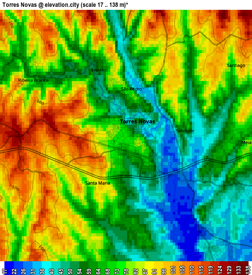
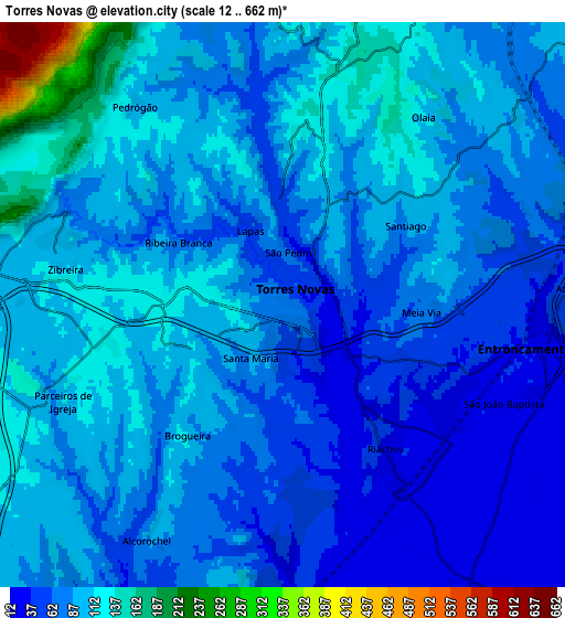
Below is the Elevation map of Torres Novas, which displays elevation range with different colors. Scale of the first map is from 17 to 138 m (56 to 453 ft) with average elevation of 72.9 meters (=239 ft) [note 1]
These maps also provides idea of topography and contour of this city, they are displayed at different zoom levels. More info about maps, scale and edge coordinates you can find below images.
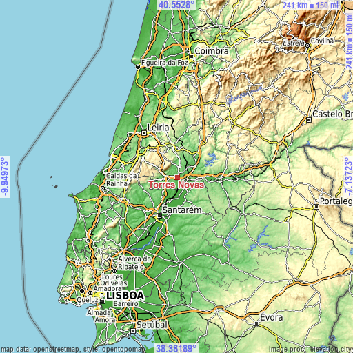
| \ | Map #1 | Map #2 | Topo.Map |
| Scale [m] | 17..138 m | 12..662 m | × |
| Scale [ft] | 56..453 ft | 39..2172 ft | × |
| Average | 72.9 m = 239 ft | 87.1 m = 286 ft | × |
| Width | 7.54 km = 4.7 mi | 15.09 km = 9.4 mi | 241.4 km = 150 mi |
| Height | 7.54 km = 4.7 mi | 15.09 km = 9.4 mi | 241.4 km = 150 mi |
| ↑Max Latitude | 39.509723° | 39.543619° | 40.5528° |
| Latitude at center | 39.47581° | 39.47581° | 39.47581° |
| ↓Min Latitude | 39.441881° | 39.407935° | 38.38189° |
| ← Min Longitude | -8.587425° | -8.631371° | -9.94973° |
| Longitude center | -8.54348° | -8.54348° | -8.54348° |
| →Max Longitude | -8.499535° | -8.455589° | -7.13723° |
Nearby cities:
Cities around Torres Novas sort by population:
• Monsanto elevation 143 m
14.5 km,  263°
263°
• Entroncamento 34 m
6.7 km,  98°
98°
• Vila Nova da Barquinha 91 m
9.4 km, 100°
• Riachos 42 m
4.3 km,  143°
143°
• Alcanena 85 m
10.9 km, 260°
• Golegã 25 m
9.3 km,  148°
148°
• Madalena 112 m
13.5 km,  38°
38°
• Minde 204 m
13.2 km,  289°
289°
• São Vicente do Paul 20 m
15.6 km,  205°
205°
• Paialvo 98 m
11.7 km,  33°
33°
• Azinhaga 19 m
14.2 km,  175°
175°
• Pinheiro Grande 46 m
13.2 km,  134°
134°
Multilingual:
 En español:
Torres Novas elevación 61 m.
 En France:
Torres Novas élévation 61 m.
 Auf Deutsch:
Torres Novas höhe über dem Meeresspiegel ist 61 m.

Sources and notes:
- [note 1] Map square and city borders are not equal. Map elevation data is calculated only from area inside that square.
- [src 1] Elevation data from geonames database provided with same terms of usage.
- [src 2] The elevation map of Torres Novas is generated using elevation data from NASA's 3 arcsec (90m) resolution SRTM data.
- [src 3] Base (background) map © OpenStreetMap contributors tiles are generated by Geofabrik and OpenTopoMap.
Copyright & License:
This Torres Novas Elevation Map is licensed under CC BY-SA. You may reuse any part from this page, if you give a proper credit by linking to this URL:
 More info on terms of use page.