Monsanto elevation
Monsanto (Santarém, Alcanena), Portugal elevation is 143 meters and Monsanto elevation in feet is 469 ft above sea level [src 1]. Monsanto is a populated place (feature code) with elevation that is 25 meters (82 ft) smaller than average city elevation in Portugal.
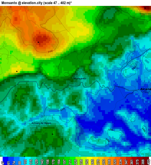
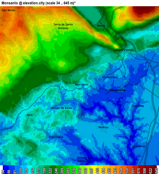
Below is the Elevation map of Monsanto, which displays elevation range with different colors. Scale of the first map is from 47 to 402 m (154 to 1319 ft) with average elevation of 160.1 meters (=525 ft) [note 1]
These maps also provides idea of topography and contour of this city, they are displayed at different zoom levels. More info about maps, scale and edge coordinates you can find below images.
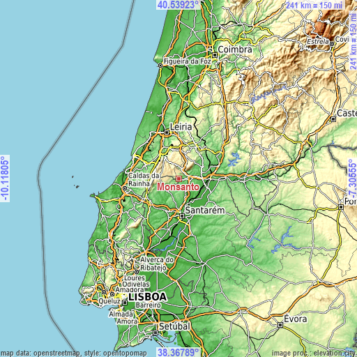
| \ | Map #1 | Map #2 | Topo.Map |
| Scale [m] | 47..402 m | 34..645 m | × |
| Scale [ft] | 154..1319 ft | 112..2116 ft | × |
| Average | 160.1 m = 525 ft | 203.6 m = 668 ft | × |
| Width | 7.54 km = 4.7 mi | 15.09 km = 9.4 mi | 241.4 km = 150 mi |
| Height | 7.54 km = 4.7 mi | 15.09 km = 9.4 mi | 241.4 km = 150 mi |
| ↑Max Latitude | 39.49595° | 39.529853° | 40.53923° |
| Latitude at center | 39.46203° | 39.46203° | 39.46203° |
| ↓Min Latitude | 39.428094° | 39.394141° | 38.36789° |
| ← Min Longitude | -8.755745° | -8.799691° | -10.11805° |
| Longitude center | -8.7118° | -8.7118° | -8.7118° |
| →Max Longitude | -8.667855° | -8.623909° | -7.30555° |
Nearby cities:
Cities around Monsanto sort by population:
• Torres Novas elevation 61 m
14.5 km,  83°
83°
• Fátima 358 m
18.4 km,  16°
16°
• Porto de Mós 136 m
18 km,  329°
329°
• Riachos 42 m
17.1 km,  96°
96°
• Alcanede 89 m
10.8 km,  241°
241°
• Alcanena 85 m
3.7 km, 95°
• Mira 255 m
9 km,  358°
358°
• Minde 204 m
6.4 km, 18°
• São Vicente do Paul 20 m
14.7 km,  148°
148°
• Vale de Figueira 58 m
18.8 km,  157°
157°
• Amiães de Baixo 125 m
2.8 km,  221°
221°
• Alcanhões 63 m
19 km,  166°
166°
Multilingual:
 En español:
Monsanto elevación 143 m.
 En France:
Monsanto élévation 143 m.
 Auf Deutsch:
Monsanto höhe über dem Meeresspiegel ist 143 m.

Sources and notes:
- [note 1] Map square and city borders are not equal. Map elevation data is calculated only from area inside that square.
- [src 1] Elevation data from geonames database provided with same terms of usage.
- [src 2] The elevation map of Monsanto is generated using elevation data from NASA's 3 arcsec (90m) resolution SRTM data.
- [src 3] Base (background) map © OpenStreetMap contributors tiles are generated by Geofabrik and OpenTopoMap.
Copyright & License:
This Monsanto Elevation Map is licensed under CC BY-SA. You may reuse any part from this page, if you give a proper credit by linking to this URL:
 More info on terms of use page.