Alcanede elevation
Alcanede (Santarém), Portugal elevation is 89 meters and Alcanede elevation in feet is 292 ft above sea level [src 1]. Alcanede is a populated place (feature code) with elevation that is 79 meters (259 ft) smaller than average city elevation in Portugal.
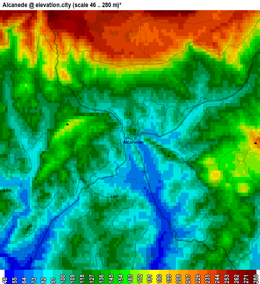
Below is the Elevation map of Alcanede, which displays elevation range with different colors. Scale of the first map is from 46 to 280 m (151 to 919 ft) with average elevation of 133.1 meters (=437 ft) [note 1]
These maps also provides idea of topography and contour of this city, they are displayed at different zoom levels. More info about maps, scale and edge coordinates you can find below images.
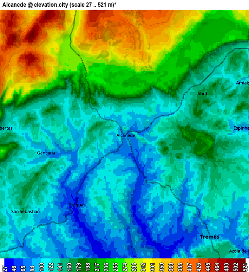
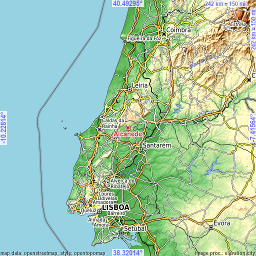
| \ | Map #1 | Map #2 | Topo.Map |
| Scale [m] | 46..280 m | 27..521 m | × |
| Scale [ft] | 151..919 ft | 89..1709 ft | × |
| Average | 133.1 m = 437 ft | 174.8 m = 573 ft | × |
| Width | 7.55 km = 4.7 mi | 15.1 km = 9.4 mi | 241.6 km = 150.1 mi |
| Height | 7.55 km = 4.7 mi | 15.1 km = 9.4 mi | 241.6 km = 150.1 mi |
| ↑Max Latitude | 39.448952° | 39.482878° | 40.49295° |
| Latitude at center | 39.41501° | 39.41501° | 39.41501° |
| ↓Min Latitude | 39.381051° | 39.347076° | 38.32014° |
| ← Min Longitude | -8.865835° | -8.909781° | -10.22814° |
| Longitude center | -8.82189° | -8.82189° | -8.82189° |
| →Max Longitude | -8.777945° | -8.733999° | -7.41564° |
Nearby cities:
Cities around Alcanede sort by population:
• Monsanto elevation 143 m
10.8 km,  61°
61°
• Rio Maior 82 m
13.3 km,  229°
229°
• Benedita 193 m
12.8 km,  274°
274°
• Aljubarrota 183 m
19.3 km,  331°
331°
• Turquel 201 m
14.4 km,  292°
292°
• Alcanena 85 m
14 km,  69°
69°
• Mira 255 m
16.9 km,  32°
32°
• Minde 204 m
16.1 km,  45°
45°
• Alvorninha 123 m
18.8 km,  258°
258°
• São Vicente do Paul 20 m
18.6 km,  113°
113°
• Amiães de Baixo 125 m
8.2 km, 67°
• Alcanhões 63 m
19.3 km,  133°
133°
Multilingual:
 En español:
Alcanede elevación 89 m.
 En France:
Alcanede élévation 89 m.


Sources and notes:
- [note 1] Map square and city borders are not equal. Map elevation data is calculated only from area inside that square.
- [src 1] Elevation data from geonames database provided with same terms of usage.
- [src 2] The elevation map of Alcanede is generated using elevation data from NASA's 3 arcsec (90m) resolution SRTM data.
- [src 3] Base (background) map © OpenStreetMap contributors tiles are generated by Geofabrik and OpenTopoMap.
Copyright & License:
This Alcanede Elevation Map is licensed under CC BY-SA. You may reuse any part from this page, if you give a proper credit by linking to this URL:
 More info on terms of use page.