Benedita elevation
Benedita (Leiria, Alcobaça), Portugal elevation is 193 meters and Benedita elevation in feet is 633 ft above sea level [src 1]. Benedita is a populated place (feature code) with elevation that is 25 meters (82 ft) bigger than average city elevation in Portugal.
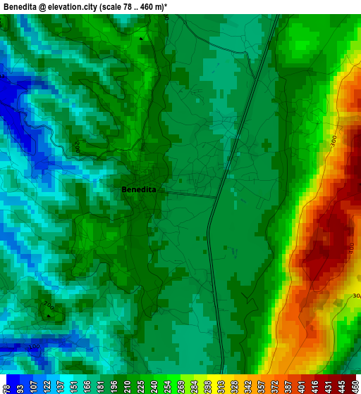
Below is the Elevation map of Benedita, which displays elevation range with different colors. Scale of the first map is from 78 to 460 m (256 to 1509 ft) with average elevation of 210.6 meters (=691 ft) [note 1]
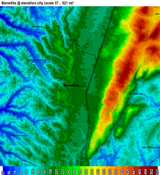
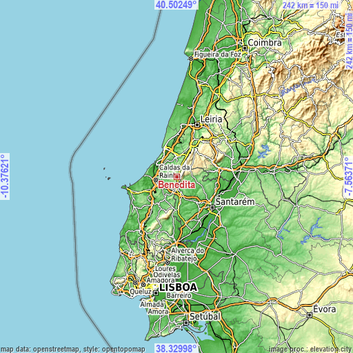
These maps also provides idea of topography and contour of this city, they are displayed at different zoom levels. More info about maps, scale and edge coordinates you can find below images.
| \ | Map #1 | Map #2 | Topo.Map |
| Scale [m] | 78..460 m | 37..521 m | × |
| Scale [ft] | 256..1509 ft | 121..1709 ft | × |
| Average | 210.6 m = 691 ft | 189.1 m = 620 ft | × |
| Width | 7.55 km = 4.7 mi | 15.1 km = 9.4 mi | 241.6 km = 150.1 mi |
| Height | 7.55 km = 4.7 mi | 15.1 km = 9.4 mi | 241.6 km = 150.1 mi |
| ↑Max Latitude | 39.458638° | 39.492559° | 40.50249° |
| Latitude at center | 39.4247° | 39.4247° | 39.4247° |
| ↓Min Latitude | 39.390746° | 39.356775° | 38.32998° |
| ← Min Longitude | -9.013905° | -9.057851° | -10.37621° |
| Longitude center | -8.96996° | -8.96996° | -8.96996° |
| →Max Longitude | -8.926015° | -8.882069° | -7.56371° |
Nearby cities:
Cities around Benedita sort by population:
• Caldas da Rainha elevation 60 m
14.7 km,  260°
260°
• Alcobaça 38 m
14.2 km,  357°
357°
• Rio Maior 82 m
10.1 km,  164°
164°
• Alcanede 89 m
12.8 km,  94°
94°
• Turquel 201 m
4.4 km,  351°
351°
• Alfeizerão 22 m
14.2 km,  306°
306°
• Cela 181 m
14 km,  336°
336°
• Alvorninha 123 m
7.4 km,  230°
230°
• Salir de Matos 47 m
10.8 km,  274°
274°
• A dos Francos 73 m
13.1 km,  210°
210°
• Vestiaria 168 m
14.4 km, 350°
• Vidais 94 m
9.2 km, 227°
Multilingual:
 En español:
Benedita elevación 193 m.
 En France:
Benedita élévation 193 m.
 Auf Deutsch:
Benedita höhe über dem Meeresspiegel ist 193 m.

Sources and notes:
- [note 1] Map square and city borders are not equal. Map elevation data is calculated only from area inside that square.
- [src 1] Elevation data from geonames database provided with same terms of usage.
- [src 2] The elevation map of Benedita is generated using elevation data from NASA's 3 arcsec (90m) resolution SRTM data.
- [src 3] Base (background) map © OpenStreetMap contributors tiles are generated by Geofabrik and OpenTopoMap.
Copyright & License:
This Benedita Elevation Map is licensed under CC BY-SA. You may reuse any part from this page, if you give a proper credit by linking to this URL:
 More info on terms of use page.