Rio Maior elevation
Rio Maior (Santarém), Portugal elevation is 82 meters and Rio Maior elevation in feet is 269 ft above sea level [src 1]. Rio Maior is a seat of a second-order administrative division (feature code) with elevation that is 86 meters (282 ft) smaller than average city elevation in Portugal.
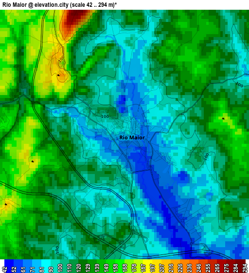
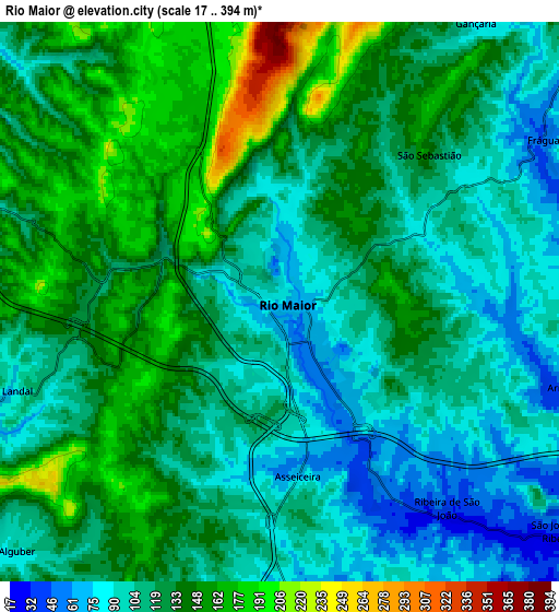
Below is the Elevation map of Rio Maior, which displays elevation range with different colors. Scale of the first map is from 42 to 294 m (138 to 965 ft) with average elevation of 115.5 meters (=379 ft) [note 1]
These maps also provides idea of topography and contour of this city, they are displayed at different zoom levels. More info about maps, scale and edge coordinates you can find below images.
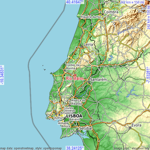
| \ | Map #1 | Map #2 | Topo.Map |
| Scale [m] | 42..294 m | 17..394 m | × |
| Scale [ft] | 138..965 ft | 56..1293 ft | × |
| Average | 115.5 m = 379 ft | 122.3 m = 401 ft | × |
| Width | 7.56 km = 4.7 mi | 15.12 km = 9.4 mi | 241.9 km = 150.3 mi |
| Height | 7.56 km = 4.7 mi | 15.12 km = 9.4 mi | 241.9 km = 150.3 mi |
| ↑Max Latitude | 39.3713° | 39.405264° | 40.41647° |
| Latitude at center | 39.33732° | 39.33732° | 39.33732° |
| ↓Min Latitude | 39.303323° | 39.26931° | 38.24125° |
| ← Min Longitude | -8.983005° | -9.026951° | -10.34531° |
| Longitude center | -8.93906° | -8.93906° | -8.93906° |
| →Max Longitude | -8.895115° | -8.851169° | -7.53281° |
Nearby cities:
Cities around Rio Maior sort by population:
• Caldas da Rainha elevation 60 m
18.6 km,  293°
293°
• Óbidos 48 m
18.9 km,  277°
277°
• Benedita 193 m
10.1 km,  344°
344°
• Bombarral 47 m
20.4 km,  247°
247°
• Alcanede 89 m
13.3 km,  49°
49°
• Turquel 201 m
14.5 km,  346°
346°
• Alcoentre 88 m
14.4 km,  187°
187°
• Alvorninha 123 m
9.8 km,  300°
300°
• Salir de Matos 47 m
17 km,  308°
308°
• Cadaval 105 m
17.6 km,  233°
233°
• A dos Francos 73 m
9.5 km,  260°
260°
• Vidais 94 m
10.1 km, 290°
Multilingual:
 En español:
Rio Maior elevación 82 m.
 En France:
Rio Maior élévation 82 m.
 Auf Deutsch:
Rio Maior höhe über dem Meeresspiegel ist 82 m.

Sources and notes:
- [note 1] Map square and city borders are not equal. Map elevation data is calculated only from area inside that square.
- [src 1] Elevation data from geonames database provided with same terms of usage.
- [src 2] The elevation map of Rio Maior is generated using elevation data from NASA's 3 arcsec (90m) resolution SRTM data.
- [src 3] Base (background) map © OpenStreetMap contributors tiles are generated by Geofabrik and OpenTopoMap.
Copyright & License:
This Rio Maior Elevation Map is licensed under CC BY-SA. You may reuse any part from this page, if you give a proper credit by linking to this URL:
 More info on terms of use page.