Alcoentre elevation
Alcoentre (Lisbon, Azambuja), Portugal elevation is 88 meters and Alcoentre elevation in feet is 289 ft above sea level [src 1]. Alcoentre is a populated place (feature code) with elevation that is 80 meters (262 ft) smaller than average city elevation in Portugal.
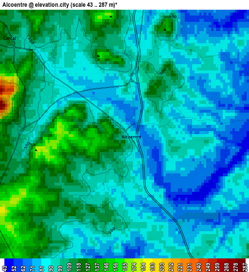
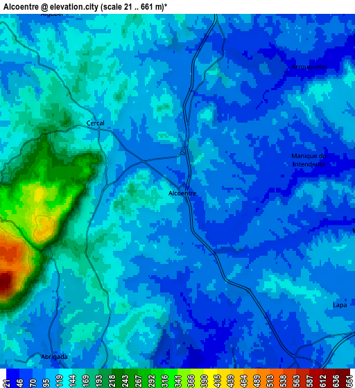
Below is the Elevation map of Alcoentre, which displays elevation range with different colors. Scale of the first map is from 43 to 287 m (141 to 942 ft) with average elevation of 96.7 meters (=317 ft) [note 1]
These maps also provides idea of topography and contour of this city, they are displayed at different zoom levels. More info about maps, scale and edge coordinates you can find below images.
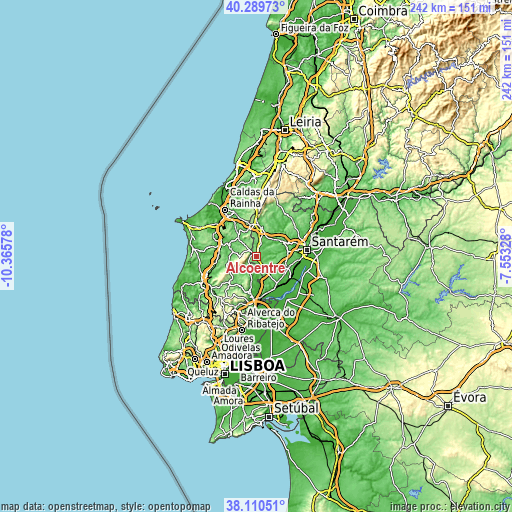
| \ | Map #1 | Map #2 | Topo.Map |
| Scale [m] | 43..287 m | 21..661 m | × |
| Scale [ft] | 141..942 ft | 69..2169 ft | × |
| Average | 96.7 m = 317 ft | 113.9 m = 374 ft | × |
| Width | 7.57 km = 4.7 mi | 15.14 km = 9.4 mi | 242.3 km = 150.6 mi |
| Height | 7.57 km = 4.7 mi | 15.14 km = 9.4 mi | 242.3 km = 150.6 mi |
| ↑Max Latitude | 39.242613° | 39.276639° | 40.28973° |
| Latitude at center | 39.20857° | 39.20857° | 39.20857° |
| ↓Min Latitude | 39.174511° | 39.140435° | 38.11051° |
| ← Min Longitude | -9.003475° | -9.047421° | -10.36578° |
| Longitude center | -8.95953° | -8.95953° | -8.95953° |
| →Max Longitude | -8.915585° | -8.871639° | -7.55328° |
Nearby cities:
Cities around Alcoentre sort by population:
• Rio Maior elevation 82 m
14.4 km,  7°
7°
• Cartaxo 59 m
15.8 km,  109°
109°
• Ventosa 133 m
14.1 km,  229°
229°
• Aveiras de Cima 60 m
9.4 km,  146°
146°
• Pontével 54 m
12.3 km,  122°
122°
• Abrigada 75 m
8.8 km,  215°
215°
• Cadaval 105 m
13 km,  287°
287°
• Meca 110 m
15.5 km,  204°
204°
• A dos Francos 73 m
14.8 km,  329°
329°
• Ota 42 m
11.1 km,  194°
194°
• Vila Verde 189 m
14.7 km,  246°
246°
• Cabanas de Torres 169 m
10.9 km,  237°
237°
Multilingual:
 En español:
Alcoentre elevación 88 m.
 En France:
Alcoentre élévation 88 m.
 Auf Deutsch:
Alcoentre höhe über dem Meeresspiegel ist 88 m.

Sources and notes:
- [note 1] Map square and city borders are not equal. Map elevation data is calculated only from area inside that square.
- [src 1] Elevation data from geonames database provided with same terms of usage.
- [src 2] The elevation map of Alcoentre is generated using elevation data from NASA's 3 arcsec (90m) resolution SRTM data.
- [src 3] Base (background) map © OpenStreetMap contributors tiles are generated by Geofabrik and OpenTopoMap.
Copyright & License:
This Alcoentre Elevation Map is licensed under CC BY-SA. You may reuse any part from this page, if you give a proper credit by linking to this URL:
 More info on terms of use page.