Cartaxo elevation
Cartaxo (Santarém), Portugal elevation is 59 meters and Cartaxo elevation in feet is 194 ft above sea level [src 1]. Cartaxo is a seat of a second-order administrative division (feature code) with elevation that is 109 meters (358 ft) smaller than average city elevation in Portugal.
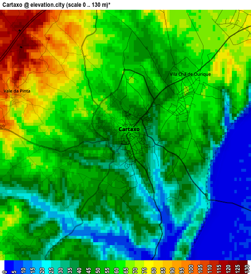
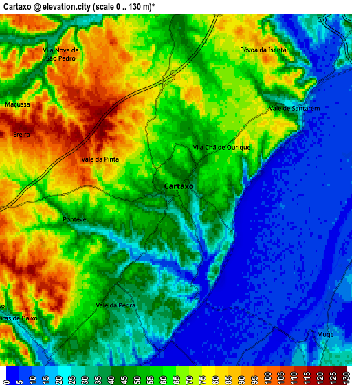
Below is the Elevation map of Cartaxo, which displays elevation range with different colors. Scale of the first map is from 0 to 130 m (0 to 427 ft) with average elevation of 49.6 meters (=163 ft) [note 1]
These maps also provides idea of topography and contour of this city, they are displayed at different zoom levels. More info about maps, scale and edge coordinates you can find below images.
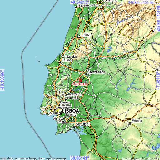
| \ | Map #1 | Map #2 | Topo.Map |
| Scale [m] | 0..130 m | 0..130 m | × |
| Scale [ft] | 0..427 ft | 0..427 ft | × |
| Average | 49.6 m = 163 ft | 46.8 m = 154 ft | × |
| Width | 7.58 km = 4.7 mi | 15.15 km = 9.4 mi | 242.5 km = 150.7 mi |
| Height | 7.58 km = 4.7 mi | 15.15 km = 9.4 mi | 242.5 km = 150.7 mi |
| ↑Max Latitude | 39.194286° | 39.228336° | 40.24213° |
| Latitude at center | 39.16022° | 39.16022° | 39.16022° |
| ↓Min Latitude | 39.126137° | 39.092038° | 38.06141° |
| ← Min Longitude | -8.831355° | -8.875301° | -10.19366° |
| Longitude center | -8.78741° | -8.78741° | -8.78741° |
| →Max Longitude | -8.743465° | -8.699519° | -7.38116° |
Nearby cities:
Cities around Cartaxo sort by population:
• Santarém elevation 107 m
12.1 km,  47°
47°
• Almeirim 38 m
14.9 km,  68°
68°
• Azambuja 25 m
12.2 km,  214°
214°
• Marinhais 34 m
14.5 km,  149°
149°
• Salvaterra de Magos 13 m
14.7 km,  182°
182°
• Aveiras de Cima 60 m
10 km,  255°
255°
• Pontével 54 m
4.6 km,  254°
254°
• Alcoentre 88 m
15.8 km,  289°
289°
• Bemfica 11 m
8.8 km,  102°
102°
• Vale de Santarém 26 m
6.2 km,  56°
56°
• Vila Chã de Ourique 66 m
2.2 km, 53°
• Ota 42 m
18.4 km, 253°
Multilingual:
 En español:
Cartaxo elevación 59 m.
 En France:
Cartaxo élévation 59 m.


Sources and notes:
- [note 1] Map square and city borders are not equal. Map elevation data is calculated only from area inside that square.
- [src 1] Elevation data from geonames database provided with same terms of usage.
- [src 2] The elevation map of Cartaxo is generated using elevation data from NASA's 3 arcsec (90m) resolution SRTM data.
- [src 3] Base (background) map © OpenStreetMap contributors tiles are generated by Geofabrik and OpenTopoMap.
Copyright & License:
This Cartaxo Elevation Map is licensed under CC BY-SA. You may reuse any part from this page, if you give a proper credit by linking to this URL:
 More info on terms of use page.