Óbidos elevation
Óbidos (Leiria), Portugal elevation is 48 meters and Óbidos elevation in feet is 157 ft above sea level [src 1]. Óbidos is a seat of a second-order administrative division (feature code) with elevation that is 120 meters (394 ft) smaller than average city elevation in Portugal.
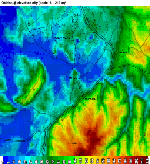
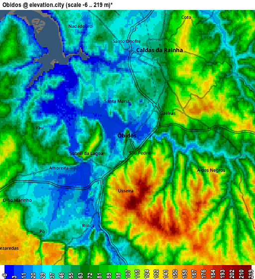
Below is the Elevation map of Óbidos, which displays elevation range with different colors. Scale of the first map is from -6 to 219 m (-20 to 719 ft) with average elevation of 62.8 meters (=206 ft) [note 1]
These maps also provides idea of topography and contour of this city, they are displayed at different zoom levels. More info about maps, scale and edge coordinates you can find below images.
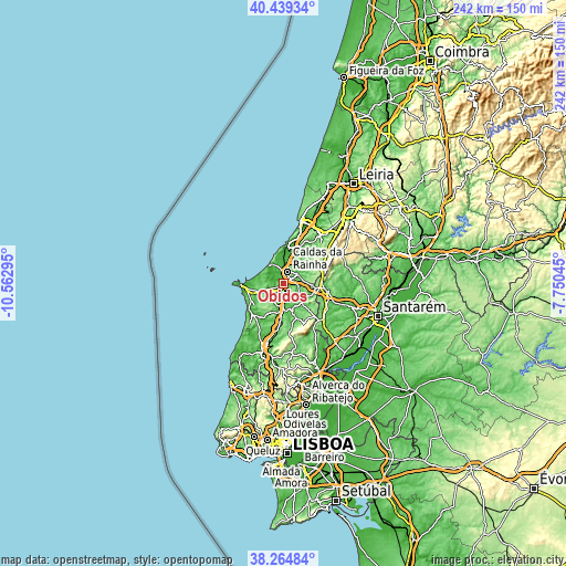
| \ | Map #1 | Map #2 | Topo.Map |
| Scale [m] | -6..219 m | -6..219 m | × |
| Scale [ft] | -20..719 ft | -20..719 ft | × |
| Average | 62.8 m = 206 ft | 73.5 m = 241 ft | × |
| Width | 7.56 km = 4.7 mi | 15.11 km = 9.4 mi | 241.8 km = 150.2 mi |
| Height | 7.56 km = 4.7 mi | 15.11 km = 9.4 mi | 241.8 km = 150.2 mi |
| ↑Max Latitude | 39.394519° | 39.428471° | 40.43934° |
| Latitude at center | 39.36055° | 39.36055° | 39.36055° |
| ↓Min Latitude | 39.326565° | 39.292563° | 38.26484° |
| ← Min Longitude | -9.200645° | -9.244591° | -10.56295° |
| Longitude center | -9.1567° | -9.1567° | -9.1567° |
| →Max Longitude | -9.112755° | -9.068809° | -7.75045° |
Nearby cities:
Cities around Óbidos sort by population:
• Caldas da Rainha elevation 60 m
5 km,  18°
18°
• Bombarral 47 m
10.4 km,  180°
180°
• Alvorninha 123 m
10.6 km,  76°
76°
• Ferrel 28 m
13.6 km,  271°
271°
• Salir de Matos 47 m
9.5 km,  33°
33°
• Cadaval 105 m
13.9 km,  160°
160°
• Nadadouro 45 m
7.2 km,  335°
335°
• Moita dos Ferreiros 93 m
13.7 km,  204°
204°
• A dos Francos 73 m
10.3 km,  114°
114°
• Serra de El-Rei 133 m
10.1 km,  252°
252°
• Foz do Arelho 22 m
9.8 km,  329°
329°
• Vidais 94 m
9.3 km, 84°
Multilingual:
 En español:
Óbidos elevación 48 m.
 En France:
Óbidos élévation 48 m.


Sources and notes:
- [note 1] Map square and city borders are not equal. Map elevation data is calculated only from area inside that square.
- [src 1] Elevation data from geonames database provided with same terms of usage.
- [src 2] The elevation map of Óbidos is generated using elevation data from NASA's 3 arcsec (90m) resolution SRTM data.
- [src 3] Base (background) map © OpenStreetMap contributors tiles are generated by Geofabrik and OpenTopoMap.
Copyright & License:
This Óbidos Elevation Map is licensed under CC BY-SA. You may reuse any part from this page, if you give a proper credit by linking to this URL:
 More info on terms of use page.