Adjuntas elevation
Adjuntas, Puerto Rico elevation is 501 meters and Adjuntas elevation in feet is 1644 ft above sea level [src 1]. Adjuntas is a seat of a first-order administrative division (feature code) with elevation that is 401 meters (1316 ft) bigger than average city elevation in Puerto Rico.
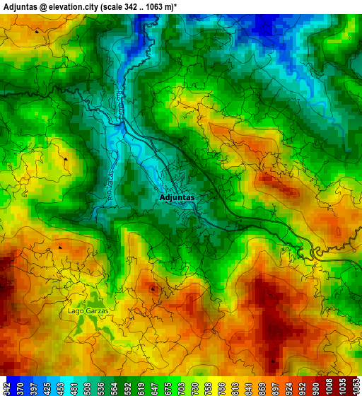
Below is the Elevation map of Adjuntas, which displays elevation range with different colors. Scale of the first map is from 342 to 1063 m (1122 to 3488 ft) with average elevation of 697.7 meters (=2289 ft) [note 1]
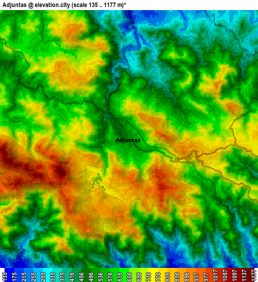
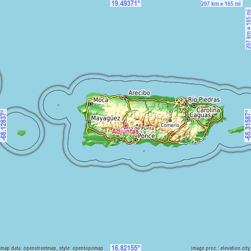
These maps also provides idea of topography and contour of this city, they are displayed at different zoom levels. More info about maps, scale and edge coordinates you can find below images.
| \ | Map #1 | Map #2 | Topo.Map |
| Scale [m] | 342..1063 m | 135..1177 m | × |
| Scale [ft] | 1122..3488 ft | 443..3862 ft | × |
| Average | 697.7 m = 2289 ft | 613.5 m = 2013 ft | × |
| Width | 9.29 km = 5.8 mi | 18.57 km = 11.5 mi | 297.1 km = 184.6 mi |
| Height | 9.29 km = 5.8 mi | 18.57 km = 11.5 mi | 297.1 km = 184.6 mi |
| ↑Max Latitude | 18.204491° | 18.246231° | 19.49371° |
| Latitude at center | 18.16274° | 18.16274° | 18.16274° |
| ↓Min Latitude | 18.120979° | 18.079209° | 16.82155° |
| ← Min Longitude | -66.766065° | -66.810011° | -68.12837° |
| Longitude center | -66.72212° | -66.72212° | -66.72212° |
| →Max Longitude | -66.678175° | -66.634229° | -65.31587° |
Nearby cities:
Cities around Adjuntas sort by population:
• Ponce elevation 16 m
19.9 km,  148°
148°
• Yauco 46 m
19.6 km,  223°
223°
• Utuado 145 m
11.7 km,  11°
11°
• Peñuelas 61 m
11.8 km,  179°
179°
• Guayanilla 16 m
17.6 km,  204°
204°
• Santo Domingo 141 m
11.5 km, 196°
• Jayuya 441 m
15.1 km,  65°
65°
• Tallaboa Alta 89 m
12.6 km,  169°
169°
• Indios 45 m
21.4 km,  208°
208°
• Cayuco 431 m
14.4 km,  352°
352°
• Tallaboa 21 m
18.7 km, 178°
• Magas Arriba 31 m
16.9 km, 197°
Multilingual:
 En español:
Adjuntas elevación 501 m.
 En France:
Adjuntas élévation 501 m.
 Auf Deutsch:
Adjuntas höhe über dem Meeresspiegel ist 501 m.

Sources and notes:
- [note 1] Map square and city borders are not equal. Map elevation data is calculated only from area inside that square.
- [src 1] Elevation data from geonames database provided with same terms of usage.
- [src 2] The elevation map of Adjuntas is generated using elevation data from NASA's 3 arcsec (90m) resolution SRTM data.
- [src 3] Base (background) map © OpenStreetMap contributors tiles are generated by Geofabrik and OpenTopoMap.
Copyright & License:
This Adjuntas Elevation Map is licensed under CC BY-SA. You may reuse any part from this page, if you give a proper credit by linking to this URL:
 More info on terms of use page.