Utuado elevation
Utuado, Puerto Rico elevation is 145 meters and Utuado elevation in feet is 476 ft above sea level [src 1]. Utuado is a seat of a first-order administrative division (feature code) with elevation that is 45 meters (148 ft) bigger than average city elevation in Puerto Rico.
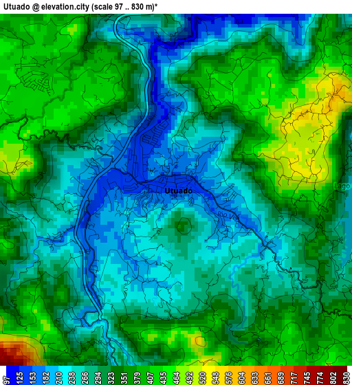
Below is the Elevation map of Utuado, which displays elevation range with different colors. Scale of the first map is from 97 to 830 m (318 to 2723 ft) with average elevation of 314.5 meters (=1032 ft) [note 1]
These maps also provides idea of topography and contour of this city, they are displayed at different zoom levels. More info about maps, scale and edge coordinates you can find below images.
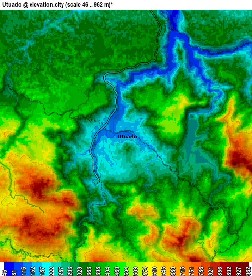
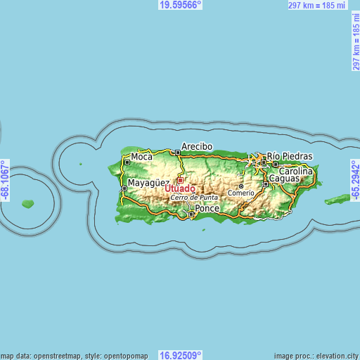
| \ | Map #1 | Map #2 | Topo.Map |
| Scale [m] | 97..830 m | 46..962 m | × |
| Scale [ft] | 318..2723 ft | 151..3156 ft | × |
| Average | 314.5 m = 1032 ft | 411.6 m = 1350 ft | × |
| Width | 9.28 km = 5.8 mi | 18.56 km = 11.5 mi | 296.9 km = 184.5 mi |
| Height | 9.28 km = 5.8 mi | 18.56 km = 11.5 mi | 297 km = 184.5 mi |
| ↑Max Latitude | 18.307236° | 18.348952° | 19.59566° |
| Latitude at center | 18.26551° | 18.26551° | 18.26551° |
| ↓Min Latitude | 18.223774° | 18.182028° | 16.92509° |
| ← Min Longitude | -66.744395° | -66.788341° | -68.1067° |
| Longitude center | -66.70045° | -66.70045° | -66.70045° |
| →Max Longitude | -66.656505° | -66.612559° | -65.2942° |
Nearby cities:
Cities around Utuado sort by population:
• Lares elevation 349 m
18.9 km,  279°
279°
• Estancias de Florida 200 m
17.8 km,  50°
50°
• Florida 193 m
18.2 km, 53°
• Adjuntas 501 m
11.7 km,  191°
191°
• Bajadero 25 m
18 km,  5°
5°
• Jayuya 441 m
12.6 km,  114°
114°
• Rafael Gonzalez 130 m
20.2 km,  333°
333°
• La Alianza 170 m
18 km,  35°
35°
• Rafael Capo 186 m
18 km, 331°
• Sabana Hoyos 98 m
20.8 km,  26°
26°
• Cayuco 431 m
5 km,  304°
304°
• Quebrada 311 m
17.2 km,  306°
306°
Multilingual:
 En español:
Utuado elevación 145 m.
 En France:
Utuado élévation 145 m.


Sources and notes:
- [note 1] Map square and city borders are not equal. Map elevation data is calculated only from area inside that square.
- [src 1] Elevation data from geonames database provided with same terms of usage.
- [src 2] The elevation map of Utuado is generated using elevation data from NASA's 3 arcsec (90m) resolution SRTM data.
- [src 3] Base (background) map © OpenStreetMap contributors tiles are generated by Geofabrik and OpenTopoMap.
Copyright & License:
This Utuado Elevation Map is licensed under CC BY-SA. You may reuse any part from this page, if you give a proper credit by linking to this URL:
 More info on terms of use page.