Ponce elevation
Ponce, Puerto Rico elevation is 16 meters and Ponce elevation in feet is 52 ft above sea level [src 1]. Ponce is a seat of a first-order administrative division (feature code) with elevation that is 84 meters (276 ft) smaller than average city elevation in Puerto Rico.
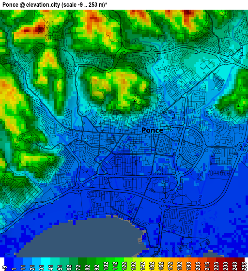
Below is the Elevation map of Ponce, which displays elevation range with different colors. Scale of the first map is from -9 to 253 m (-30 to 830 ft) with average elevation of 48 meters (=157 ft) [note 1]
These maps also provides idea of topography and contour of this city, they are displayed at different zoom levels. More info about maps, scale and edge coordinates you can find below images.
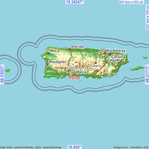
| \ | Map #1 | Map #2 | Topo.Map |
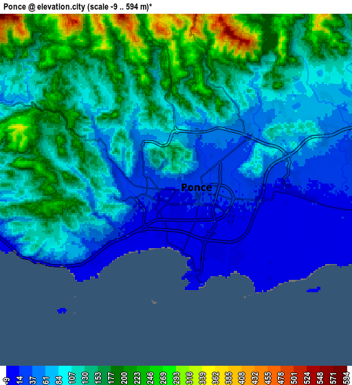
| Scale [m] | -9..253 m | -9..594 m | × |
| Scale [ft] | -30..830 ft | -30..1949 ft | × |
| Average | 48 m = 157 ft | 115.8 m = 380 ft | × |
| Width | 9.29 km = 5.8 mi | 18.59 km = 11.6 mi | 297.4 km = 184.8 mi |
| Height | 9.29 km = 5.8 mi | 18.59 km = 11.6 mi | 297.4 km = 184.8 mi |
| ↑Max Latitude | 18.052097° | 18.093874° | 19.34247° |
| Latitude at center | 18.01031° | 18.01031° | 18.01031° |
| ↓Min Latitude | 17.968513° | 17.926706° | 16.668° |
| ← Min Longitude | -66.667925° | -66.711871° | -68.03023° |
| Longitude center | -66.62398° | -66.62398° | -66.62398° |
| →Max Longitude | -66.580035° | -66.536089° | -65.21773° |
Nearby cities:
Cities around Ponce sort by population:
• Juana Díaz elevation 50 m
13.3 km,  69°
69°
• Peñuelas 61 m
11.5 km,  296°
296°
• Aguilita 29 m
9.6 km,  81°
81°
• Potala Pastillo 4 m
13.6 km,  98°
98°
• Santo Domingo 141 m
14.8 km,  293°
293°
• Coto Laurel 71 m
8.8 km,  60°
60°
• Luis Llorens Torres 81 m
11.5 km, 63°
• Capitanejo 19 m
9.6 km,  87°
87°
• Guayabal 79 m
15.2 km, 58°
• Tallaboa Alta 89 m
9.2 km, 299°
• Tallaboa 21 m
9.9 km,  260°
260°
• Magas Arriba 31 m
15.4 km,  272°
272°
Multilingual:
 En español:
Ponce elevación 16 m.
 En France:
Ponce élévation 16 m.


Sources and notes:
- [note 1] Map square and city borders are not equal. Map elevation data is calculated only from area inside that square.
- [src 1] Elevation data from geonames database provided with same terms of usage.
- [src 2] The elevation map of Ponce is generated using elevation data from NASA's 3 arcsec (90m) resolution SRTM data.
- [src 3] Base (background) map © OpenStreetMap contributors tiles are generated by Geofabrik and OpenTopoMap.
Copyright & License:
This Ponce Elevation Map is licensed under CC BY-SA. You may reuse any part from this page, if you give a proper credit by linking to this URL:
 More info on terms of use page.