Chynów elevation
Chynów (Mazovia, Powiat grójecki), Poland elevation is 118 meters and Chynów elevation in feet is 387 ft above sea level [src 1]. Chynów is a seat of a third-order administrative division (feature code) with elevation that is 73 meters (240 ft) smaller than average city elevation in Poland.
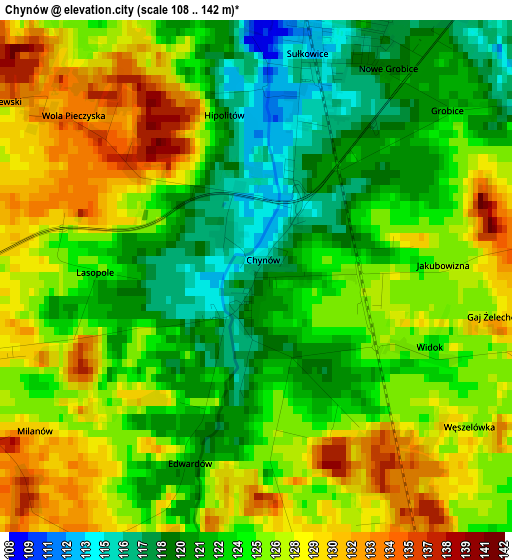
Below is the Elevation map of Chynów, which displays elevation range with different colors. Scale of the first map is from 108 to 142 m (354 to 466 ft) with average elevation of 124.6 meters (=409 ft) [note 1]
These maps also provides idea of topography and contour of this city, they are displayed at different zoom levels. More info about maps, scale and edge coordinates you can find below images.
| \ | Map #1 | Topo.Map |
| Scale [m] | 108..142 m | × |
| Scale [ft] | 354..466 ft | × |
| Average | 124.6 m = 409 ft | × |
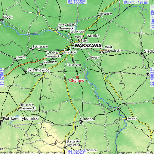
| Width | 6.03 km = 3.7 mi | 192.9 km = 119.9 mi |
| Height | 6.03 km = 3.7 mi | 192.9 km = 119.9 mi |
| ↑Max Latitude | 51.931355° | 52.76352° |
| Latitude at center | 51.90425° | 51.90425° |
| ↓Min Latitude | 51.877129° | 51.02823° |
| ← Min Longitude | 21.038135° | 19.67583° |
| Longitude center | 21.08208° | 21.08208° |
| →Max Longitude | 21.126025° | 22.48833° |
Nearby cities:
Cities around Chynów sort by population:
• Piaseczno elevation 108 m
20.1 km,  348°
348°
• Grójec 153 m
15.4 km,  252°
252°
• Warka 115 m
15.3 km,  150°
150°
• Góra Kalwaria 113 m
12.2 km,  48°
48°
• Baniocha 109 m
13.1 km,  17°
17°
• Tarczyn 145 m
19.1 km,  296°
296°
• Zalesie Górne 115 m
14.1 km, 347°
• Żabieniec 99 m
17.3 km, 352°
• Jasieniec 137 m
13.4 km,  226°
226°
• Sułkowice 112 m
2.2 km,  13°
13°
• Sobienie Jeziory 97 m
15.5 km,  78°
78°
• Prażmów 120 m
9.6 km,  294°
294°
Multilingual:
 En español:
Chynów elevación 118 m.
 En France:
Chynów élévation 118 m.


Sources and notes:
- [note 1] Map square and city borders are not equal. Map elevation data is calculated only from area inside that square.
- [src 1] Elevation data from geonames database provided with same terms of usage.
- [src 2] The elevation map of Chynów is generated using elevation data from NASA's 3 arcsec (90m) resolution SRTM data.
- [src 3] Base (background) map © OpenStreetMap contributors tiles are generated by Geofabrik and OpenTopoMap.
Copyright & License:
This Chynów Elevation Map is licensed under CC BY-SA. You may reuse any part from this page, if you give a proper credit by linking to this URL:
 More info on terms of use page.