Grójec elevation
Grójec (Mazovia, Powiat grójecki), Poland elevation is 153 meters and Grójec elevation in feet is 502 ft above sea level [src 1]. Grójec is a seat of a third-order administrative division (feature code) with elevation that is 38 meters (125 ft) smaller than average city elevation in Poland.
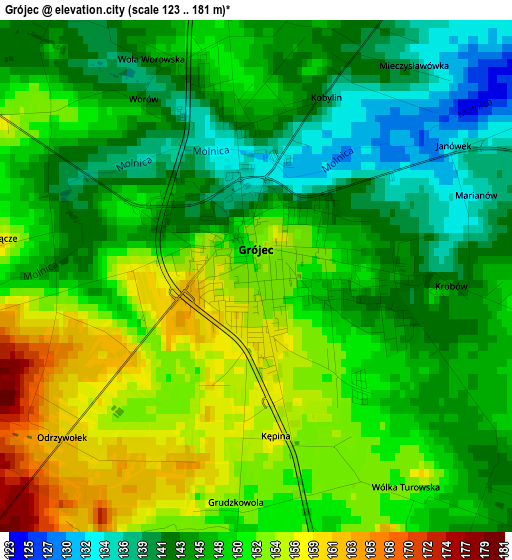
Below is the Elevation map of Grójec, which displays elevation range with different colors. Scale of the first map is from 123 to 181 m (404 to 594 ft) with average elevation of 148 meters (=486 ft) [note 1]
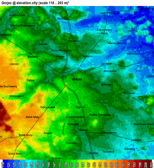
These maps also provides idea of topography and contour of this city, they are displayed at different zoom levels. More info about maps, scale and edge coordinates you can find below images.
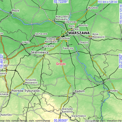
| \ | Map #1 | Map #2 | Topo.Map |
| Scale [m] | 123..181 m | 118..203 m | × |
| Scale [ft] | 404..594 ft | 387..666 ft | × |
| Average | 148 m = 486 ft | 147.3 m = 483 ft | × |
| Width | 6.03 km = 3.7 mi | 12.07 km = 7.5 mi | 193.1 km = 120 mi |
| Height | 6.04 km = 3.8 mi | 12.07 km = 7.5 mi | 193.1 km = 120 mi |
| ↑Max Latitude | 51.88965° | 51.916764° | 52.72259° |
| Latitude at center | 51.86252° | 51.86252° | 51.86252° |
| ↓Min Latitude | 51.835373° | 51.80821° | 50.98569° |
| ← Min Longitude | 20.823625° | 20.779679° | 19.46132° |
| Longitude center | 20.86757° | 20.86757° | 20.86757° |
| →Max Longitude | 20.911515° | 20.955461° | 22.27382° |
Nearby cities:
Cities around Grójec sort by population:
• Tarczyn elevation 145 m
13.5 km,  350°
350°
• Zalesie Górne 115 m
21.7 km,  32°
32°
• Mogielnica 135 m
21.2 km,  208°
208°
• Jasieniec 137 m
6.8 km,  132°
132°
• Sułkowice 112 m
16.6 km,  66°
66°
• Błędów 156 m
15 km,  231°
231°
• Goszczyn 142 m
14.6 km,  184°
184°
• Prażmów 120 m
10.5 km, 34°
• Chynów 118 m
15.4 km, 72°
• Promna 118 m
21.2 km,  162°
162°
• Pniewy 174 m
10.2 km,  304°
304°
• Belsk Duży 176 m
5.8 km,  224°
224°
Multilingual:
 En español:
Grójec elevación 153 m.
 En France:
Grójec élévation 153 m.


Sources and notes:
- [note 1] Map square and city borders are not equal. Map elevation data is calculated only from area inside that square.
- [src 1] Elevation data from geonames database provided with same terms of usage.
- [src 2] The elevation map of Grójec is generated using elevation data from NASA's 3 arcsec (90m) resolution SRTM data.
- [src 3] Base (background) map © OpenStreetMap contributors tiles are generated by Geofabrik and OpenTopoMap.
Copyright & License:
This Grójec Elevation Map is licensed under CC BY-SA. You may reuse any part from this page, if you give a proper credit by linking to this URL:
 More info on terms of use page.