Baniocha elevation
Baniocha (Mazovia, Powiat piaseczyński), Poland elevation is 109 meters and Baniocha elevation in feet is 358 ft above sea level [src 1]. Baniocha is a populated place (feature code) with elevation that is 82 meters (269 ft) smaller than average city elevation in Poland.
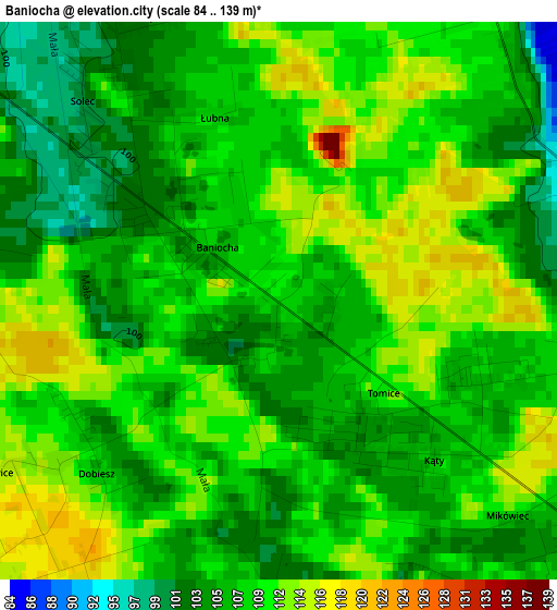
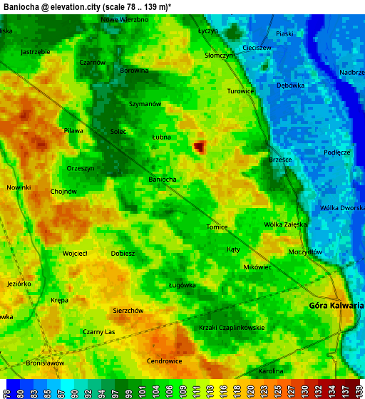
Below is the Elevation map of Baniocha, which displays elevation range with different colors. Scale of the first map is from 84 to 139 m (276 to 456 ft) with average elevation of 108.4 meters (=356 ft) [note 1]
These maps also provides idea of topography and contour of this city, they are displayed at different zoom levels. More info about maps, scale and edge coordinates you can find below images.
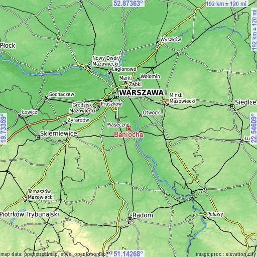
| \ | Map #1 | Map #2 | Topo.Map |
| Scale [m] | 84..139 m | 78..139 m | × |
| Scale [ft] | 276..456 ft | 256..456 ft | × |
| Average | 108.4 m = 356 ft | 105.5 m = 346 ft | × |
| Width | 6.01 km = 3.7 mi | 12.03 km = 7.5 mi | 192.5 km = 119.6 mi |
| Height | 6.01 km = 3.7 mi | 12.03 km = 7.5 mi | 192.4 km = 119.6 mi |
| ↑Max Latitude | 52.043567° | 52.070588° | 52.87363° |
| Latitude at center | 52.01653° | 52.01653° | 52.01653° |
| ↓Min Latitude | 51.989476° | 51.962406° | 51.14268° |
| ← Min Longitude | 21.095895° | 21.051949° | 19.73359° |
| Longitude center | 21.13984° | 21.13984° | 21.13984° |
| →Max Longitude | 21.183785° | 21.227731° | 22.54609° |
Nearby cities:
Cities around Baniocha sort by population:
• Otwock elevation 94 m
12.9 km,  39°
39°
• Piaseczno 108 m
10.7 km,  312°
312°
• Kabaty 97 m
13.2 km,  342°
342°
• Konstancin-Jeziorna 89 m
8.7 km,  349°
349°
• Góra Kalwaria 113 m
6.8 km,  130°
130°
• Karczew 90 m
10 km,  48°
48°
• Józefosław 96 m
11.3 km,  325°
325°
• Zalesie Górne 115 m
7.2 km,  279°
279°
• Mysiadło 106 m
12.6 km,  318°
318°
• Żabieniec 99 m
7.8 km, 306°
• Sułkowice 112 m
11 km,  198°
198°
• Chynów 118 m
13.1 km, 197°
Multilingual:
 En español:
Baniocha elevación 109 m.
 En France:
Baniocha élévation 109 m.
 Auf Deutsch:
Baniocha höhe über dem Meeresspiegel ist 109 m.

Sources and notes:
- [note 1] Map square and city borders are not equal. Map elevation data is calculated only from area inside that square.
- [src 1] Elevation data from geonames database provided with same terms of usage.
- [src 2] The elevation map of Baniocha is generated using elevation data from NASA's 3 arcsec (90m) resolution SRTM data.
- [src 3] Base (background) map © OpenStreetMap contributors tiles are generated by Geofabrik and OpenTopoMap.
Copyright & License:
This Baniocha Elevation Map is licensed under CC BY-SA. You may reuse any part from this page, if you give a proper credit by linking to this URL:
 More info on terms of use page.