Mniszków elevation
Mniszków (Łódź Voivodeship, Powiat opoczyński), Poland elevation is 220 meters and Mniszków elevation in feet is 722 ft above sea level [src 1]. Mniszków is a seat of a third-order administrative division (feature code) with elevation that is 29 meters (95 ft) bigger than average city elevation in Poland.
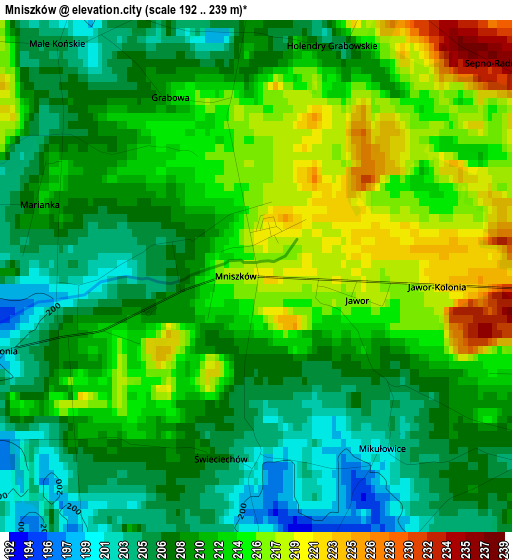
Below is the Elevation map of Mniszków, which displays elevation range with different colors. Scale of the first map is from 192 to 239 m (630 to 784 ft) with average elevation of 210.9 meters (=692 ft) [note 1]
These maps also provides idea of topography and contour of this city, they are displayed at different zoom levels. More info about maps, scale and edge coordinates you can find below images.
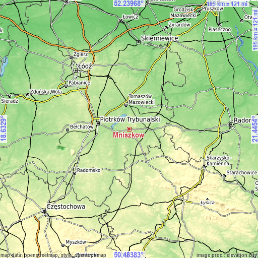
| \ | Map #1 | Topo.Map |
| Scale [m] | 192..239 m | × |
| Scale [ft] | 630..784 ft | × |
| Average | 210.9 m = 692 ft | × |
| Width | 6.1 km = 3.8 mi | 195.2 km = 121.3 mi |
| Height | 6.1 km = 3.8 mi | 195.2 km = 121.3 mi |
| ↑Max Latitude | 51.397596° | 52.23968° |
| Latitude at center | 51.37017° | 51.37017° |
| ↓Min Latitude | 51.342727° | 50.48383° |
| ← Min Longitude | 19.995205° | 18.6329° |
| Longitude center | 20.03915° | 20.03915° |
| →Max Longitude | 20.083095° | 21.4454° |
Nearby cities:
Cities around Mniszków sort by population:
• Piotrków Trybunalski elevation 194 m
23.6 km,  279°
279°
• Tomaszów Mazowiecki 164 m
18 km,  353°
353°
• Opoczno 193 m
16.6 km,  87°
87°
• Sulejów 168 m
10.8 km,  260°
260°
• Wolbórz 171 m
20.6 km,  315°
315°
• Białaczów 207 m
19.6 km,  114°
114°
• Żarnów 239 m
16.7 km,  145°
145°
• Inowłódz 152 m
21.6 km,  36°
36°
• Ręczno 217 m
23.8 km,  212°
212°
• Paradyż 193 m
8.8 km,  143°
143°
• Sławno 212 m
7.5 km,  70°
70°
• Aleksandrów 207 m
11.5 km,  197°
197°
Multilingual:
 En español:
Mniszków elevación 220 m.
 En France:
Mniszków élévation 220 m.
 Auf Deutsch:
Mniszków höhe über dem Meeresspiegel ist 220 m.

Sources and notes:
- [note 1] Map square and city borders are not equal. Map elevation data is calculated only from area inside that square.
- [src 1] Elevation data from geonames database provided with same terms of usage.
- [src 2] The elevation map of Mniszków is generated using elevation data from NASA's 3 arcsec (90m) resolution SRTM data.
- [src 3] Base (background) map © OpenStreetMap contributors tiles are generated by Geofabrik and OpenTopoMap.
Copyright & License:
This Mniszków Elevation Map is licensed under CC BY-SA. You may reuse any part from this page, if you give a proper credit by linking to this URL:
 More info on terms of use page.