Inowłódz elevation
Inowłódz (Łódź Voivodeship, Powiat tomaszowski), Poland elevation is 152 meters and Inowłódz elevation in feet is 499 ft above sea level [src 1]. Inowłódz is a seat of a third-order administrative division (feature code) with elevation that is 39 meters (128 ft) smaller than average city elevation in Poland.
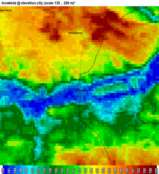
Below is the Elevation map of Inowłódz, which displays elevation range with different colors. Scale of the first map is from 139 to 200 m (456 to 656 ft) with average elevation of 167.9 meters (=551 ft) [note 1]
These maps also provides idea of topography and contour of this city, they are displayed at different zoom levels. More info about maps, scale and edge coordinates you can find below images.
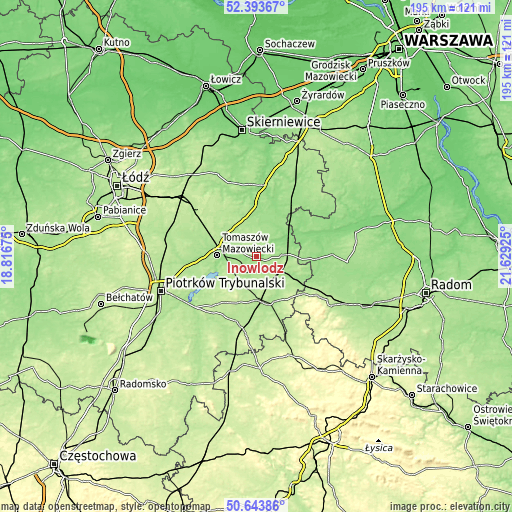
| \ | Map #1 | Topo.Map |
| Scale [m] | 139..200 m | × |
| Scale [ft] | 456..656 ft | × |
| Average | 167.9 m = 551 ft | × |
| Width | 6.08 km = 3.8 mi | 194.6 km = 120.9 mi |
| Height | 6.08 km = 3.8 mi | 194.5 km = 120.9 mi |
| ↑Max Latitude | 51.554502° | 52.39367° |
| Latitude at center | 51.52717° | 51.52717° |
| ↓Min Latitude | 51.499822° | 50.64386° |
| ← Min Longitude | 20.179055° | 18.81675° |
| Longitude center | 20.223° | 20.223° |
| →Max Longitude | 20.266945° | 21.62925° |
Nearby cities:
Cities around Inowłódz sort by population:
• Tomaszów Mazowiecki elevation 164 m
14.8 km,  271°
271°
• Opoczno 193 m
17.3 km,  167°
167°
• Drzewica 161 m
19.5 km,  115°
115°
• Ujazd 174 m
22.2 km,  290°
290°
• Rzeczyca 164 m
9.3 km,  32°
32°
• Gielniów 199 m
22.8 km,  128°
128°
• Cielądz 148 m
22.6 km,  21°
21°
• Czerniewice 175 m
14.9 km,  341°
341°
• Lubochnia 176 m
14.7 km,  307°
307°
• Mniszków 220 m
21.6 km,  216°
216°
• Poświętne 163 m
9.8 km,  86°
86°
• Sławno 212 m
16 km,  200°
200°
Multilingual:
 En español:
Inowłódz elevación 152 m.
 En France:
Inowłódz élévation 152 m.
 Auf Deutsch:
Inowłódz höhe über dem Meeresspiegel ist 152 m.

Sources and notes:
- [note 1] Map square and city borders are not equal. Map elevation data is calculated only from area inside that square.
- [src 1] Elevation data from geonames database provided with same terms of usage.
- [src 2] The elevation map of Inowłódz is generated using elevation data from NASA's 3 arcsec (90m) resolution SRTM data.
- [src 3] Base (background) map © OpenStreetMap contributors tiles are generated by Geofabrik and OpenTopoMap.
Copyright & License:
This Inowłódz Elevation Map is licensed under CC BY-SA. You may reuse any part from this page, if you give a proper credit by linking to this URL:
 More info on terms of use page.