Białaczów elevation
Białaczów (Łódź Voivodeship, Powiat opoczyński), Poland elevation is 207 meters and Białaczów elevation in feet is 679 ft above sea level [src 1]. Białaczów is a seat of a third-order administrative division (feature code) with elevation that is 16 meters (52 ft) bigger than average city elevation in Poland.
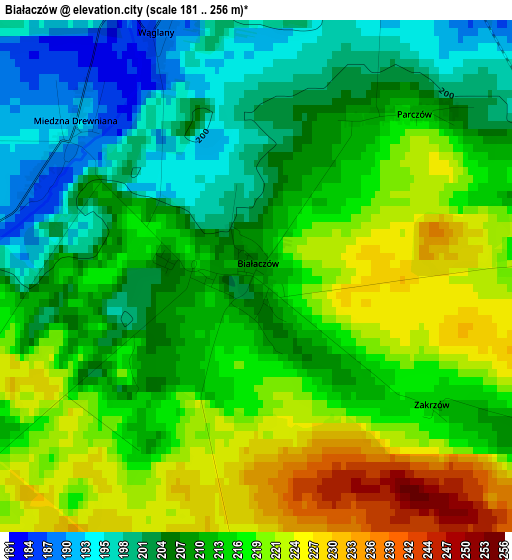
Below is the Elevation map of Białaczów, which displays elevation range with different colors. Scale of the first map is from 181 to 256 m (594 to 840 ft) with average elevation of 212.3 meters (=697 ft) [note 1]
These maps also provides idea of topography and contour of this city, they are displayed at different zoom levels. More info about maps, scale and edge coordinates you can find below images.
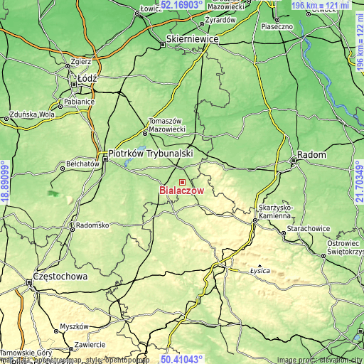
| \ | Map #1 | Topo.Map |
| Scale [m] | 181..256 m | × |
| Scale [ft] | 594..840 ft | × |
| Average | 212.3 m = 697 ft | × |
| Width | 6.11 km = 3.8 mi | 195.5 km = 121.5 mi |
| Height | 6.11 km = 3.8 mi | 195.5 km = 121.5 mi |
| ↑Max Latitude | 51.325619° | 52.16903° |
| Latitude at center | 51.29815° | 51.29815° |
| ↓Min Latitude | 51.270664° | 50.41043° |
| ← Min Longitude | 20.253295° | 18.89099° |
| Longitude center | 20.29724° | 20.29724° |
| →Max Longitude | 20.341185° | 21.70349° |
Nearby cities:
Cities around Białaczów sort by population:
• Opoczno elevation 193 m
8.7 km,  351°
351°
• Końskie 249 m
14.1 km,  147°
147°
• Drzewica 161 m
21.1 km,  36°
36°
• Gowarczów 235 m
10.1 km,  102°
102°
• Rogów 236 m
14.2 km,  137°
137°
• Gielniów 199 m
17.1 km,  48°
48°
• Żarnów 239 m
10.3 km,  235°
235°
• Ruda Maleniecka 217 m
17.7 km,  196°
196°
• Paradyż 193 m
12.8 km,  273°
273°
• Mniszków 220 m
19.6 km,  294°
294°
• Sławno 212 m
15.1 km,  313°
313°
• Aleksandrów 207 m
21.6 km,  262°
262°
Multilingual:
 En español:
Białaczów elevación 207 m.
 En France:
Białaczów élévation 207 m.
 Auf Deutsch:
Białaczów höhe über dem Meeresspiegel ist 207 m.

Sources and notes:
- [note 1] Map square and city borders are not equal. Map elevation data is calculated only from area inside that square.
- [src 1] Elevation data from geonames database provided with same terms of usage.
- [src 2] The elevation map of Białaczów is generated using elevation data from NASA's 3 arcsec (90m) resolution SRTM data.
- [src 3] Base (background) map © OpenStreetMap contributors tiles are generated by Geofabrik and OpenTopoMap.
Copyright & License:
This Białaczów Elevation Map is licensed under CC BY-SA. You may reuse any part from this page, if you give a proper credit by linking to this URL:
 More info on terms of use page.