Aco elevation
Aco (Junin, Provincia de Concepción), Peru elevation is 3469 meters and Aco elevation in feet is 11381 ft above sea level [src 1]. Aco is a seat of a third-order administrative division (feature code) with elevation that is 1148 meters (3766 ft) bigger than average city elevation in Peru.
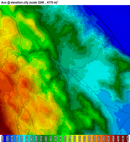
Below is the Elevation map of Aco, which displays elevation range with different colors. Scale of the first map is from 3248 to 4170 m (10656 to 13681 ft) with average elevation of 3594.5 meters (=11793 ft) [note 1]
These maps also provides idea of topography and contour of this city, they are displayed at different zoom levels. More info about maps, scale and edge coordinates you can find below images.
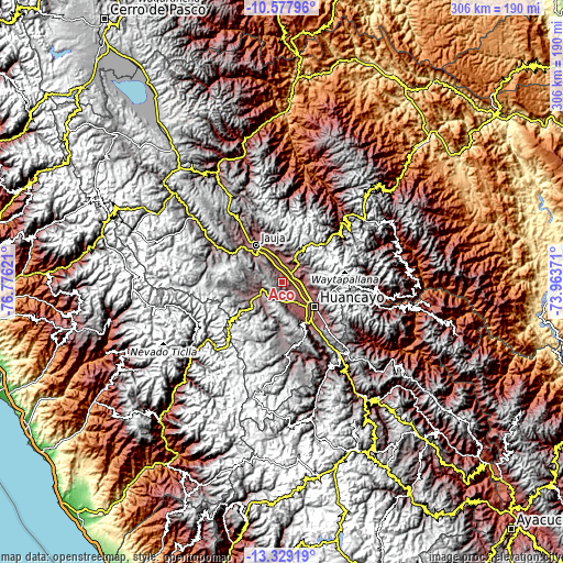
| \ | Map #1 | Topo.Map |
| Scale [m] | 3248..4170 m | × |
| Scale [ft] | 10656..13681 ft | × |
| Average | 3594.5 m = 11793 ft | × |
| Width | 9.56 km = 5.9 mi | 305.9 km = 190.1 mi |
| Height | 9.56 km = 5.9 mi | 305.9 km = 190.1 mi |
| ↑Max Latitude | -11.914075° | -10.57796° |
| Latitude at center | -11.95707° | -11.95707° |
| ↓Min Latitude | -12.000058° | -13.32919° |
| ← Min Longitude | -75.413905° | -76.77621° |
| Longitude center | -75.36996° | -75.36996° |
| →Max Longitude | -75.326015° | -73.96371° |
Nearby cities:
Cities around Aco sort by population:
• Concepción elevation 3287 m
7.5 km,  54°
54°
• San Jerónimo 3250 m
9.3 km,  89°
89°
• Orcotuna 3250 m
6.9 km,  100°
100°
• Ahuac 3581 m
12.4 km,  169°
169°
• San Lorenzo 3309 m
12.3 km,  354°
354°
• Saño 3289 m
12.3 km, 89°
• Quilcas 3321 m
12.2 km,  78°
78°
• Quichuay 3405 m
11.8 km, 50°
• Apata 3340 m
11.5 km,  8°
8°
• Matahuasi 3289 m
7.8 km,  21°
21°
• Sincos 3300 m
7.6 km, 345°
• Chambara 3548 m
6.8 km,  192°
192°
Multilingual:
 En español:
Aco elevación 3469 m.
 En France:
Aco élévation 3469 m.


Sources and notes:
- [note 1] Map square and city borders are not equal. Map elevation data is calculated only from area inside that square.
- [src 1] Elevation data from geonames database provided with same terms of usage.
- [src 2] The elevation map of Aco is generated using elevation data from NASA's 3 arcsec (90m) resolution SRTM data.
- [src 3] Base (background) map © OpenStreetMap contributors tiles are generated by Geofabrik and OpenTopoMap.
Copyright & License:
This Aco Elevation Map is licensed under CC BY-SA. You may reuse any part from this page, if you give a proper credit by linking to this URL:
 More info on terms of use page.