Sincos elevation
Sincos (Junin, Provincia de Jauja), Peru elevation is 3300 meters and Sincos elevation in feet is 10827 ft above sea level [src 1]. Sincos is a seat of a third-order administrative division (feature code) with elevation that is 979 meters (3212 ft) bigger than average city elevation in Peru.
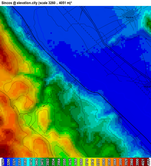
Below is the Elevation map of Sincos, which displays elevation range with different colors. Scale of the first map is from 3260 to 4051 m (10696 to 13291 ft) with average elevation of 3461.3 meters (=11356 ft) [note 1]
These maps also provides idea of topography and contour of this city, they are displayed at different zoom levels. More info about maps, scale and edge coordinates you can find below images.
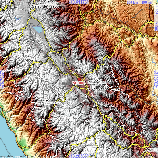
| \ | Map #1 | Topo.Map |
| Scale [m] | 3260..4051 m | × |
| Scale [ft] | 10696..13291 ft | × |
| Average | 3461.3 m = 11356 ft | × |
| Width | 9.56 km = 5.9 mi | 306 km = 190.1 mi |
| Height | 9.56 km = 5.9 mi | 306 km = 190.1 mi |
| ↑Max Latitude | -11.848184° | -10.51176° |
| Latitude at center | -11.89119° | -11.89119° |
| ↓Min Latitude | -11.934189° | -13.26366° |
| ← Min Longitude | -75.431395° | -76.7937° |
| Longitude center | -75.38745° | -75.38745° |
| →Max Longitude | -75.343505° | -73.9812° |
Nearby cities:
Cities around Sincos sort by population:
• Concepción elevation 3287 m
8.5 km,  110°
110°
• Orcotuna 3250 m
12.2 km,  134°
134°
• Masma Chicche 3643 m
11.7 km,  4°
4°
• Ataura 3342 m
11.5 km,  330°
330°
• Muquiyauyo 3345 m
11.3 km,  319°
319°
• Quichuay 3405 m
11.1 km,  89°
89°
• Huamali 3336 m
10.2 km,  336°
336°
• Muqui 3327 m
8.2 km, 321°
• Aco 3469 m
7.6 km,  165°
165°
• Apata 3340 m
5.5 km,  42°
42°
• San Lorenzo 3309 m
5 km,  7°
7°
• Matahuasi 3289 m
4.8 km, 90°
Multilingual:
 En español:
Sincos elevación 3300 m.
 En France:
Sincos élévation 3300 m.


Sources and notes:
- [note 1] Map square and city borders are not equal. Map elevation data is calculated only from area inside that square.
- [src 1] Elevation data from geonames database provided with same terms of usage.
- [src 2] The elevation map of Sincos is generated using elevation data from NASA's 3 arcsec (90m) resolution SRTM data.
- [src 3] Base (background) map © OpenStreetMap contributors tiles are generated by Geofabrik and OpenTopoMap.
Copyright & License:
This Sincos Elevation Map is licensed under CC BY-SA. You may reuse any part from this page, if you give a proper credit by linking to this URL:
 More info on terms of use page.