Orcotuna elevation
Orcotuna (Junin, Provincia de Concepción), Peru elevation is 3250 meters and Orcotuna elevation in feet is 10663 ft above sea level [src 1]. Orcotuna is a populated place (feature code) with elevation that is 929 meters (3048 ft) bigger than average city elevation in Peru.
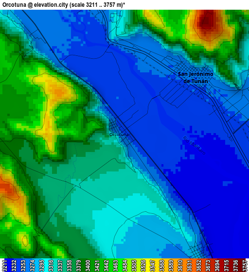
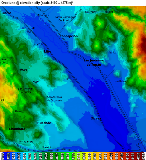
Below is the Elevation map of Orcotuna, which displays elevation range with different colors. Scale of the first map is from 3211 to 3757 m (10535 to 12326 ft) with average elevation of 3328.1 meters (=10919 ft) [note 1]
These maps also provides idea of topography and contour of this city, they are displayed at different zoom levels. More info about maps, scale and edge coordinates you can find below images.
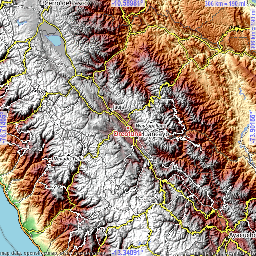
| \ | Map #1 | Map #2 | Topo.Map |
| Scale [m] | 3211..3757 m | 3190..4275 m | × |
| Scale [ft] | 10535..12326 ft | 10466..14026 ft | × |
| Average | 3328.1 m = 10919 ft | 3422.9 m = 11230 ft | × |
| Width | 9.56 km = 5.9 mi | 19.12 km = 11.9 mi | 305.9 km = 190.1 mi |
| Height | 9.56 km = 5.9 mi | 19.12 km = 11.9 mi | 305.9 km = 190.1 mi |
| ↑Max Latitude | -11.925867° | -11.882866° | -10.58981° |
| Latitude at center | -11.96886° | -11.96886° | -11.96886° |
| ↓Min Latitude | -12.011847° | -12.054826° | -13.34091° |
| ← Min Longitude | -75.351745° | -75.395691° | -76.71405° |
| Longitude center | -75.3078° | -75.3078° | -75.3078° |
| →Max Longitude | -75.263855° | -75.219909° | -73.90155° |
Nearby cities:
Cities around Orcotuna sort by population:
• Concepción elevation 3287 m
5.7 km,  353°
353°
• San Jerónimo 3250 m
3 km,  60°
60°
• Sicaya 3252 m
7.6 km,  159°
159°
• San Agustin 3257 m
5.7 km,  93°
93°
• Ingenio 3466 m
9.9 km,  27°
27°
• Chambara 3548 m
9.8 km,  237°
237°
• Matahuasi 3289 m
9.4 km,  335°
335°
• Quichuay 3405 m
9.1 km,  15°
15°
• Aco 3469 m
6.9 km,  280°
280°
• Quilcas 3321 m
6.4 km,  54°
54°
• Hualhuas 3264 m
6.2 km, 92°
• Saño 3289 m
5.7 km,  76°
76°
Multilingual:
 En español:
Orcotuna elevación 3250 m.
 En France:
Orcotuna élévation 3250 m.
 Auf Deutsch:
Orcotuna höhe über dem Meeresspiegel ist 3250 m.

Sources and notes:
- [note 1] Map square and city borders are not equal. Map elevation data is calculated only from area inside that square.
- [src 1] Elevation data from geonames database provided with same terms of usage.
- [src 2] The elevation map of Orcotuna is generated using elevation data from NASA's 3 arcsec (90m) resolution SRTM data.
- [src 3] Base (background) map © OpenStreetMap contributors tiles are generated by Geofabrik and OpenTopoMap.
Copyright & License:
This Orcotuna Elevation Map is licensed under CC BY-SA. You may reuse any part from this page, if you give a proper credit by linking to this URL:
 More info on terms of use page.