San Agustin elevation
San Agustin (Junin, Provincia de Huancayo), Peru elevation is 3257 meters and San Agustin elevation in feet is 10686 ft above sea level [src 1]. San Agustin is a seat of a third-order administrative division (feature code) with elevation that is 936 meters (3071 ft) bigger than average city elevation in Peru.
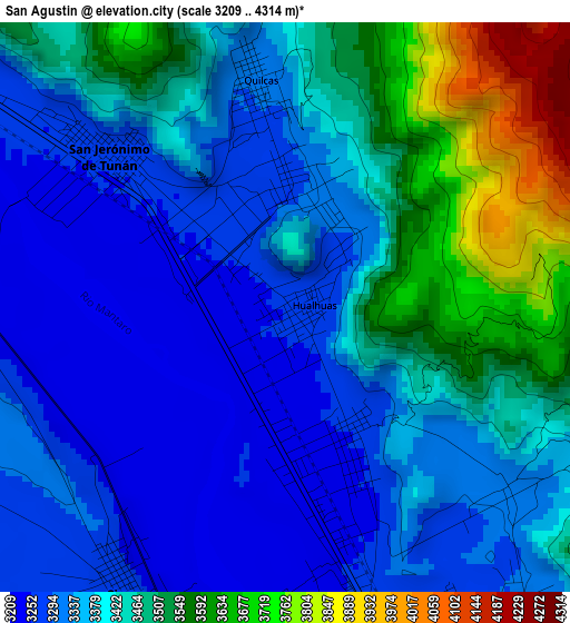
Below is the Elevation map of San Agustin, which displays elevation range with different colors. Scale of the first map is from 3209 to 4314 m (10528 to 14154 ft) with average elevation of 3406.3 meters (=11176 ft) [note 1]
These maps also provides idea of topography and contour of this city, they are displayed at different zoom levels. More info about maps, scale and edge coordinates you can find below images.
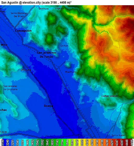
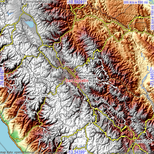
| \ | Map #1 | Map #2 | Topo.Map |
| Scale [m] | 3209..4314 m | 3190..4498 m | × |
| Scale [ft] | 10528..14154 ft | 10466..14757 ft | × |
| Average | 3406.3 m = 11176 ft | 3516.5 m = 11537 ft | × |
| Width | 9.56 km = 5.9 mi | 19.12 km = 11.9 mi | 305.9 km = 190.1 mi |
| Height | 9.56 km = 5.9 mi | 19.12 km = 11.9 mi | 305.9 km = 190.1 mi |
| ↑Max Latitude | -11.928957° | -11.885957° | -10.59291° |
| Latitude at center | -11.97195° | -11.97195° | -11.97195° |
| ↓Min Latitude | -12.014936° | -12.057915° | -13.34399° |
| ← Min Longitude | -75.299565° | -75.343511° | -76.66187° |
| Longitude center | -75.25562° | -75.25562° | -75.25562° |
| →Max Longitude | -75.211675° | -75.167729° | -73.84937° |
Nearby cities:
Cities around San Agustin sort by population:
• Concepción elevation 3287 m
8.8 km,  313°
313°
• Chupaca 3254 m
11 km,  195°
195°
• San Jerónimo 3250 m
3.6 km,  299°
299°
• Pilcomay 3205 m
8.4 km,  175°
175°
• Sicaya 3252 m
7.5 km, 203°
• Orcotuna 3250 m
5.7 km,  273°
273°
• El Tambo 3249 m
11.4 km,  158°
158°
• Quichuay 3405 m
9.7 km,  340°
340°
• Ingenio 3466 m
9.2 km,  353°
353°
• Quilcas 3321 m
4 km, 353°
• Saño 3289 m
1.7 km,  355°
355°
• Hualhuas 3264 m
0.5 km,  84°
84°
Multilingual:
 En español:
San Agustin elevación 3257 m.
 En France:
San Agustin élévation 3257 m.
 Auf Deutsch:
San Agustin höhe über dem Meeresspiegel ist 3257 m.

Sources and notes:
- [note 1] Map square and city borders are not equal. Map elevation data is calculated only from area inside that square.
- [src 1] Elevation data from geonames database provided with same terms of usage.
- [src 2] The elevation map of San Agustin is generated using elevation data from NASA's 3 arcsec (90m) resolution SRTM data.
- [src 3] Base (background) map © OpenStreetMap contributors tiles are generated by Geofabrik and OpenTopoMap.
Copyright & License:
This San Agustin Elevation Map is licensed under CC BY-SA. You may reuse any part from this page, if you give a proper credit by linking to this URL:
 More info on terms of use page.