Ahuac elevation
Ahuac (Junin, Provincia de Chupaca), Peru elevation is 3581 meters and Ahuac elevation in feet is 11749 ft above sea level [src 1]. Ahuac is a seat of a third-order administrative division (feature code) with elevation that is 1260 meters (4134 ft) bigger than average city elevation in Peru.
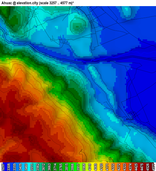
Below is the Elevation map of Ahuac, which displays elevation range with different colors. Scale of the first map is from 3257 to 4577 m (10686 to 15016 ft) with average elevation of 3703.8 meters (=12152 ft) [note 1]
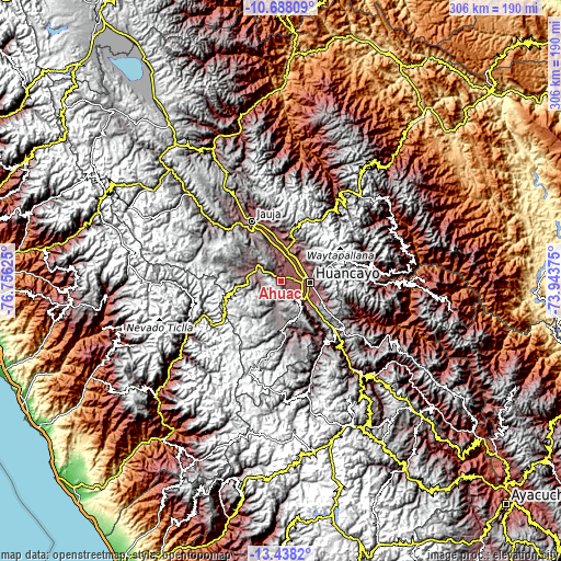
These maps also provides idea of topography and contour of this city, they are displayed at different zoom levels. More info about maps, scale and edge coordinates you can find below images.
| \ | Map #1 | Topo.Map |
| Scale [m] | 3257..4577 m | × |
| Scale [ft] | 10686..15016 ft | × |
| Average | 3703.8 m = 12152 ft | × |
| Width | 9.56 km = 5.9 mi | 305.8 km = 190 mi |
| Height | 9.56 km = 5.9 mi | 305.8 km = 190 mi |
| ↑Max Latitude | -12.023692° | -10.68809° |
| Latitude at center | -12.06667° | -12.06667° |
| ↓Min Latitude | -12.109641° | -13.4382° |
| ← Min Longitude | -75.393945° | -76.75625° |
| Longitude center | -75.35° | -75.35° |
| →Max Longitude | -75.306055° | -73.94375° |
Nearby cities:
Cities around Ahuac sort by population:
• Chupaca elevation 3254 m
7.2 km,  90°
90°
• San Jerónimo 3250 m
14.2 km,  30°
30°
• Pilcomay 3205 m
11.2 km,  78°
78°
• Sicaya 3252 m
8.1 km,  62°
62°
• San Agustin 3257 m
14.7 km,  44°
44°
• Huayucachi 3170 m
14.7 km,  120°
120°
• Orcotuna 3250 m
11.8 km,  22°
22°
• Hualhuas 3264 m
15.1 km,  45°
45°
• El Tambo 3249 m
14.5 km, 90°
• Jarpa 4184 m
13.8 km,  246°
246°
• Aco 3469 m
12.4 km,  349°
349°
• Chambara 3548 m
6.6 km,  326°
326°
Multilingual:
 En español:
Ahuac elevación 3581 m.
 En France:
Ahuac élévation 3581 m.


Sources and notes:
- [note 1] Map square and city borders are not equal. Map elevation data is calculated only from area inside that square.
- [src 1] Elevation data from geonames database provided with same terms of usage.
- [src 2] The elevation map of Ahuac is generated using elevation data from NASA's 3 arcsec (90m) resolution SRTM data.
- [src 3] Base (background) map © OpenStreetMap contributors tiles are generated by Geofabrik and OpenTopoMap.
Copyright & License:
This Ahuac Elevation Map is licensed under CC BY-SA. You may reuse any part from this page, if you give a proper credit by linking to this URL:
 More info on terms of use page.