Moquegua elevation
Moquegua, Peru elevation is 1445 meters and Moquegua elevation in feet is 4741 ft above sea level [src 1]. Moquegua is a seat of a first-order administrative division (feature code) with elevation that is 876 meters (2874 ft) smaller than average city elevation in Peru.
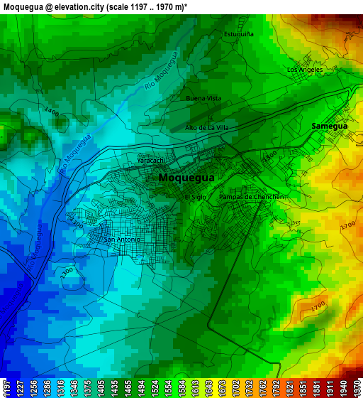
Below is the Elevation map of Moquegua, which displays elevation range with different colors. Scale of the first map is from 1197 to 1970 m (3927 to 6463 ft) with average elevation of 1459 meters (=4787 ft) [note 1]
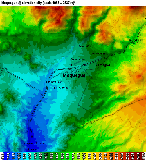
These maps also provides idea of topography and contour of this city, they are displayed at different zoom levels. More info about maps, scale and edge coordinates you can find below images.
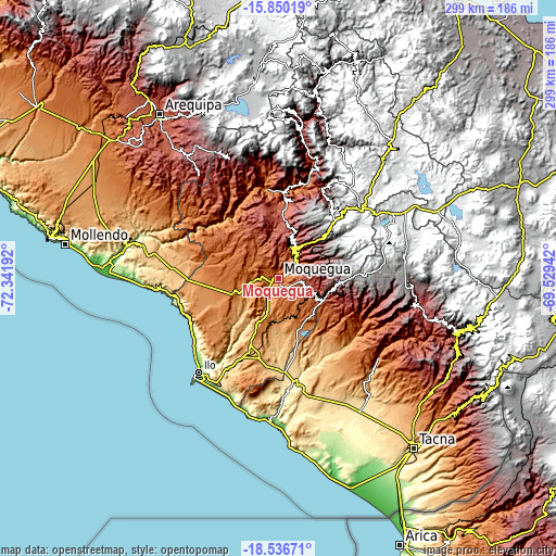
| \ | Map #1 | Map #2 | Topo.Map |
| Scale [m] | 1197..1970 m | 1085..2537 m | × |
| Scale [ft] | 3927..6463 ft | 3560..8323 ft | × |
| Average | 1459 m = 4787 ft | 1651.2 m = 5417 ft | × |
| Width | 9.34 km = 5.8 mi | 18.67 km = 11.6 mi | 298.7 km = 185.6 mi |
| Height | 9.34 km = 5.8 mi | 18.67 km = 11.6 mi | 298.7 km = 185.6 mi |
| ↑Max Latitude | -17.156335° | -17.11434° | -15.85019° |
| Latitude at center | -17.19832° | -17.19832° | -17.19832° |
| ↓Min Latitude | -17.240296° | -17.282262° | -18.53671° |
| ← Min Longitude | -70.979615° | -71.023561° | -72.34192° |
| Longitude center | -70.93567° | -70.93567° | -70.93567° |
| →Max Longitude | -70.891725° | -70.847779° | -69.52942° |
Nearby cities:
Cities around Moquegua sort by population:
• Ilabaya elevation 1386 m
51.2 km,  118°
118°
• Torata 2213 m
16.7 km,  36°
36°
• Camilaca 3285 m
59.7 km,  97°
97°
• El Algarrobal 125 m
58.9 km,  216°
216°
• Omate 2036 m
57.5 km,  354°
354°
• Cuchumbaya 3125 m
56.6 km,  28°
28°
• Calacoa 2914 m
55.8 km, 26°
• La Capilla 1842 m
55.5 km,  332°
332°
• Quinistaquillas 1767 m
50.2 km,  6°
6°
• Locumba 598 m
49.7 km,  158°
158°
• Carumas 3552 m
48.4 km, 28°
• Samegua 1576 m
4.4 km,  61°
61°
Multilingual:
 En español:
Moquegua elevación 1445 m.
 En France:
Moquegua élévation 1445 m.
 Auf Deutsch:
Moquegua höhe über dem Meeresspiegel ist 1445 m.

Sources and notes:
- [note 1] Map square and city borders are not equal. Map elevation data is calculated only from area inside that square.
- [src 1] Elevation data from geonames database provided with same terms of usage.
- [src 2] The elevation map of Moquegua is generated using elevation data from NASA's 3 arcsec (90m) resolution SRTM data.
- [src 3] Base (background) map © OpenStreetMap contributors tiles are generated by Geofabrik and OpenTopoMap.
Copyright & License:
This Moquegua Elevation Map is licensed under CC BY-SA. You may reuse any part from this page, if you give a proper credit by linking to this URL:
 More info on terms of use page.