Carumas elevation
Carumas (Moquegua, Provincia de Mariscal Nieto), Peru elevation is 3552 meters and Carumas elevation in feet is 11654 ft above sea level [src 1]. Carumas is a seat of a third-order administrative division (feature code) with elevation that is 1231 meters (4039 ft) bigger than average city elevation in Peru.
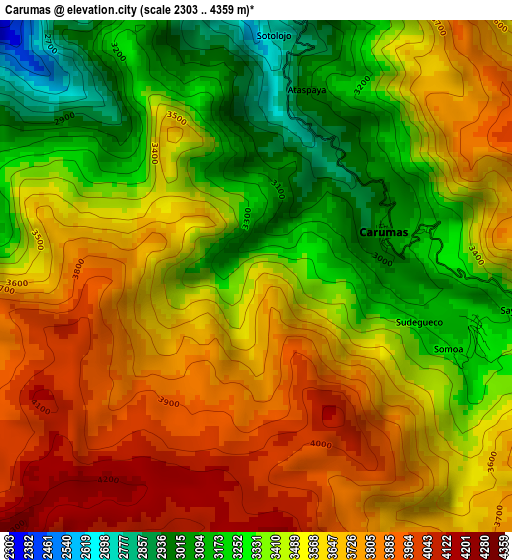
Below is the Elevation map of Carumas, which displays elevation range with different colors. Scale of the first map is from 2303 to 4359 m (7556 to 14301 ft) with average elevation of 3517.2 meters (=11539 ft) [note 1]
These maps also provides idea of topography and contour of this city, they are displayed at different zoom levels. More info about maps, scale and edge coordinates you can find below images.
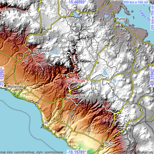
| \ | Map #1 | Topo.Map |
| Scale [m] | 2303..4359 m | × |
| Scale [ft] | 7556..14301 ft | × |
| Average | 3517.2 m = 11539 ft | × |
| Width | 9.35 km = 5.8 mi | 299.3 km = 186 mi |
| Height | 9.35 km = 5.8 mi | 299.3 km = 186 mi |
| ↑Max Latitude | -16.774599° | -15.46589° |
| Latitude at center | -16.81667° | -16.81667° |
| ↓Min Latitude | -16.858731° | -18.15789° |
| ← Min Longitude | -70.760615° | -72.12292° |
| Longitude center | -70.71667° | -70.71667° |
| →Max Longitude | -70.672725° | -69.31042° |
Nearby cities:
Cities around Carumas sort by population:
• Moquegua elevation 1445 m
48.4 km,  208°
208°
• Torata 2213 m
31.9 km,  204°
204°
• La Capilla 1842 m
49.7 km,  277°
277°
• Ubinas 3483 m
49 km,  340°
340°
• Chojata 4165 m
46.4 km,  357°
357°
• Samegua 1576 m
44.7 km, 205°
• Matalaque 2761 m
38.6 km, 343°
• Coalaque 2276 m
37.3 km,  299°
299°
• Omate 2036 m
32 km, 297°
• Quinistaquillas 1767 m
19.2 km,  292°
292°
• Cuchumbaya 3125 m
8.2 km,  25°
25°
• Calacoa 2914 m
7.6 km,  13°
13°
Multilingual:
 En español:
Carumas elevación 3552 m.
 En France:
Carumas élévation 3552 m.
 Auf Deutsch:
Carumas höhe über dem Meeresspiegel ist 3552 m.

Sources and notes:
- [note 1] Map square and city borders are not equal. Map elevation data is calculated only from area inside that square.
- [src 1] Elevation data from geonames database provided with same terms of usage.
- [src 2] The elevation map of Carumas is generated using elevation data from NASA's 3 arcsec (90m) resolution SRTM data.
- [src 3] Base (background) map © OpenStreetMap contributors tiles are generated by Geofabrik and OpenTopoMap.
Copyright & License:
This Carumas Elevation Map is licensed under CC BY-SA. You may reuse any part from this page, if you give a proper credit by linking to this URL:
 More info on terms of use page.