Locumba elevation
Locumba (Tacna, Jorge Basadre), Peru elevation is 598 meters and Locumba elevation in feet is 1962 ft above sea level [src 1]. Locumba is a seat of a third-order administrative division (feature code) with elevation that is 1723 meters (5653 ft) smaller than average city elevation in Peru.
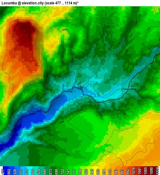
Below is the Elevation map of Locumba, which displays elevation range with different colors. Scale of the first map is from 477 to 1114 m (1565 to 3655 ft) with average elevation of 747.3 meters (=2452 ft) [note 1]
These maps also provides idea of topography and contour of this city, they are displayed at different zoom levels. More info about maps, scale and edge coordinates you can find below images.
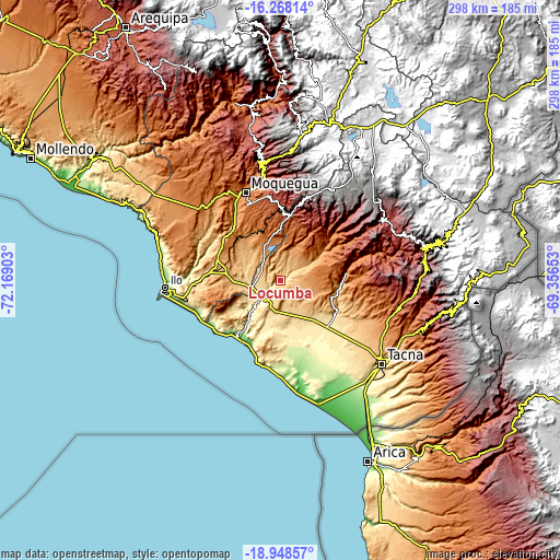
| \ | Map #1 | Topo.Map |
| Scale [m] | 477..1114 m | × |
| Scale [ft] | 1565..3655 ft | × |
| Average | 747.3 m = 2452 ft | × |
| Width | 9.31 km = 5.8 mi | 298 km = 185.2 mi |
| Height | 9.31 km = 5.8 mi | 298.1 km = 185.2 mi |
| ↑Max Latitude | -17.57144° | -16.26814° |
| Latitude at center | -17.61333° | -17.61333° |
| ↓Min Latitude | -17.65521° | -18.94857° |
| ← Min Longitude | -70.806725° | -72.16903° |
| Longitude center | -70.76278° | -70.76278° |
| →Max Longitude | -70.718835° | -69.35653° |
Nearby cities:
Cities around Locumba sort by population:
• Moquegua elevation 1445 m
49.7 km,  338°
338°
• Ilabaya 1386 m
34 km,  51°
51°
• Totoral 1979 m
48.1 km,  61°
61°
• Chipispaya 1940 m
59.3 km,  77°
77°
• Huanuara 3244 m
57.4 km, 54°
• Camilaca 3285 m
56 km, 46°
• Cairani 3394 m
55.8 km, 49°
• El Algarrobal 125 m
53.5 km,  268°
268°
• Curibaya 2402 m
52.1 km, 60°
• Samegua 1576 m
50.4 km, 343°
• Las Yaras 390 m
35 km,  142°
142°
• Sama Grande 520 m
34.7 km,  125°
125°
Multilingual:
 En español:
Locumba elevación 598 m.
 En France:
Locumba élévation 598 m.


Sources and notes:
- [note 1] Map square and city borders are not equal. Map elevation data is calculated only from area inside that square.
- [src 1] Elevation data from geonames database provided with same terms of usage.
- [src 2] The elevation map of Locumba is generated using elevation data from NASA's 3 arcsec (90m) resolution SRTM data.
- [src 3] Base (background) map © OpenStreetMap contributors tiles are generated by Geofabrik and OpenTopoMap.
Copyright & License:
This Locumba Elevation Map is licensed under CC BY-SA. You may reuse any part from this page, if you give a proper credit by linking to this URL:
 More info on terms of use page.