San Vicente de Cañete elevation
San Vicente de Cañete (Lima region, Provincia de Cañete), Peru elevation is 45 meters and San Vicente de Cañete elevation in feet is 148 ft above sea level [src 1]. San Vicente de Cañete is a populated place (feature code) with elevation that is 2276 meters (7467 ft) smaller than average city elevation in Peru.
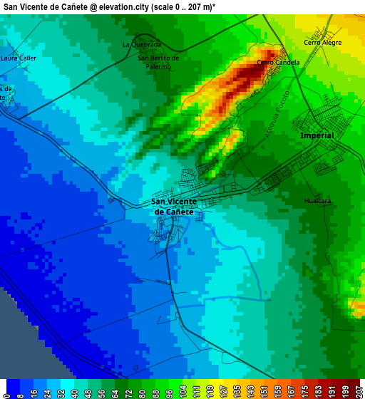
Below is the Elevation map of San Vicente de Cañete, which displays elevation range with different colors. Scale of the first map is from 0 to 207 m (0 to 679 ft) with average elevation of 52.2 meters (=171 ft) [note 1]
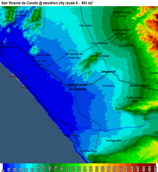
These maps also provides idea of topography and contour of this city, they are displayed at different zoom levels. More info about maps, scale and edge coordinates you can find below images.
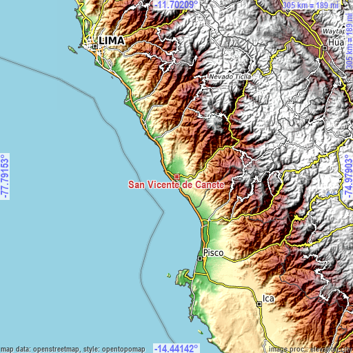
| \ | Map #1 | Map #2 | Topo.Map |
| Scale [m] | 0..207 m | 0..503 m | × |
| Scale [ft] | 0..679 ft | 0..1650 ft | × |
| Average | 52.2 m = 171 ft | 103.8 m = 341 ft | × |
| Width | 9.52 km = 5.9 mi | 19.04 km = 11.8 mi | 304.6 km = 189.3 mi |
| Height | 9.52 km = 5.9 mi | 19.04 km = 11.8 mi | 304.6 km = 189.3 mi |
| ↑Max Latitude | -13.03275° | -12.989933° | -11.70209° |
| Latitude at center | -13.07556° | -13.07556° | -13.07556° |
| ↓Min Latitude | -13.118362° | -13.161157° | -14.44142° |
| ← Min Longitude | -76.429225° | -76.473171° | -77.79153° |
| Longitude center | -76.38528° | -76.38528° | -76.38528° |
| →Max Longitude | -76.341335° | -76.297389° | -74.97903° |
Nearby cities:
Cities around San Vicente de Cañete sort by population:
• Chincha Alta elevation 111 m
46.2 km,  143°
143°
• Nuevo Imperial 153 m
7.4 km,  89°
89°
• Imperial 91 m
4 km,  62°
62°
• Mala 34 m
53.5 km,  330°
330°
• Quilmaná 162 m
14.1 km,  1°
1°
• Chocos 2710 m
59.4 km,  72°
72°
• El Carmen 146 m
58.8 km, 142°
• Chincha Baja 35 m
48.9 km,  150°
150°
• Sunampe 67 m
45.9 km, 148°
• San Pedro 93 m
43.5 km, 145°
• Coayllo 260 m
39.1 km,  346°
346°
• Asia 26 m
38 km, 328°
Multilingual:
 En español:
San Vicente de Cañete elevación 45 m.
 En France:
San Vicente de Cañete élévation 45 m.
 Auf Deutsch:
San Vicente de Cañete höhe über dem Meeresspiegel ist 45 m.
 На русском:
San Vicente de Cañete высота над уровнем моря 45 м
Sources and notes:
- [note 1] Map square and city borders are not equal. Map elevation data is calculated only from area inside that square.
- [src 1] Elevation data from geonames database provided with same terms of usage.
- [src 2] The elevation map of San Vicente de Cañete is generated using elevation data from NASA's 3 arcsec (90m) resolution SRTM data.
- [src 3] Base (background) map © OpenStreetMap contributors tiles are generated by Geofabrik and OpenTopoMap.
Copyright & License:
This San Vicente de Cañete Elevation Map is licensed under CC BY-SA. You may reuse any part from this page, if you give a proper credit by linking to this URL:
 More info on terms of use page.