Chincha Alta elevation
Chincha Alta (Ica, Provincia de Chincha), Peru elevation is 111 meters and Chincha Alta elevation in feet is 364 ft above sea level [src 1]. Chincha Alta is a seat of a third-order administrative division (feature code) with elevation that is 2210 meters (7251 ft) smaller than average city elevation in Peru.
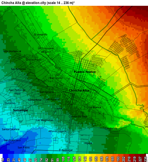
Below is the Elevation map of Chincha Alta, which displays elevation range with different colors. Scale of the first map is from 14 to 236 m (46 to 774 ft) with average elevation of 111.4 meters (=365 ft) [note 1]
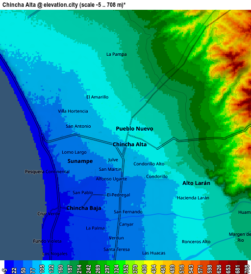
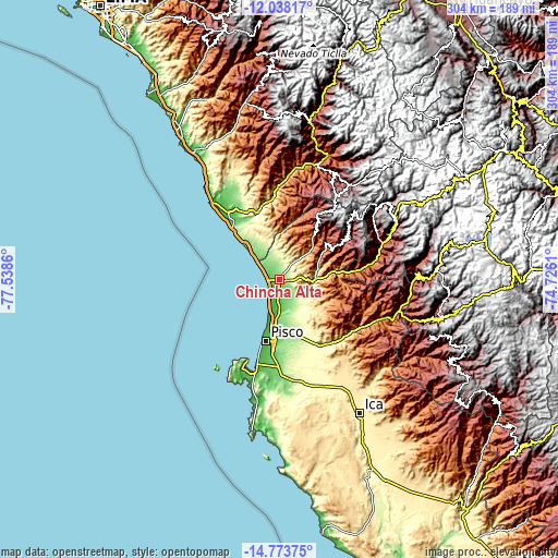
These maps also provides idea of topography and contour of this city, they are displayed at different zoom levels. More info about maps, scale and edge coordinates you can find below images.
| \ | Map #1 | Map #2 | Topo.Map |
| Scale [m] | 14..236 m | -5..708 m | × |
| Scale [ft] | 46..774 ft | -16..2323 ft | × |
| Average | 111.4 m = 365 ft | 162.5 m = 533 ft | × |
| Width | 9.51 km = 5.9 mi | 19.01 km = 11.8 mi | 304.2 km = 189 mi |
| Height | 9.51 km = 5.9 mi | 19.01 km = 11.8 mi | 304.2 km = 189 mi |
| ↑Max Latitude | -13.367099° | -13.32434° | -12.03817° |
| Latitude at center | -13.40985° | -13.40985° | -13.40985° |
| ↓Min Latitude | -13.452593° | -13.495329° | -14.77375° |
| ← Min Longitude | -76.176295° | -76.220241° | -77.5386° |
| Longitude center | -76.13235° | -76.13235° | -76.13235° |
| →Max Longitude | -76.088405° | -76.044459° | -74.7261° |
Nearby cities:
Cities around Chincha Alta sort by population:
• Pisco elevation 19 m
34.3 km,  193°
193°
• Imperial 91 m
45.7 km,  328°
328°
• Nuevo Imperial 153 m
42.2 km, 331°
• San Vicente de Cañete 45 m
46.2 km,  323°
323°
• San Clemente 80 m
28.6 km,  183°
183°
• Villa Tupac Amaru 82 m
33.6 km, 183°
• Humay 496 m
42.4 km,  143°
143°
• Independencia 190 m
34 km,  161°
161°
• El Carmen 146 m
12.7 km, 140°
• Chincha Baja 35 m
6.4 km,  211°
211°
• Sunampe 67 m
3.9 km,  240°
240°
• San Pedro 93 m
3.1 km,  292°
292°
Multilingual:
 En español:
Chincha Alta elevación 111 m.
 En France:
Chincha Alta élévation 111 m.
 Auf Deutsch:
Chincha Alta höhe über dem Meeresspiegel ist 111 m.

Sources and notes:
- [note 1] Map square and city borders are not equal. Map elevation data is calculated only from area inside that square.
- [src 1] Elevation data from geonames database provided with same terms of usage.
- [src 2] The elevation map of Chincha Alta is generated using elevation data from NASA's 3 arcsec (90m) resolution SRTM data.
- [src 3] Base (background) map © OpenStreetMap contributors tiles are generated by Geofabrik and OpenTopoMap.
Copyright & License:
This Chincha Alta Elevation Map is licensed under CC BY-SA. You may reuse any part from this page, if you give a proper credit by linking to this URL:
 More info on terms of use page.