Mala elevation
Mala (Lima region, Provincia de Cañete), Peru elevation is 34 meters and Mala elevation in feet is 112 ft above sea level [src 1]. Mala is a seat of a third-order administrative division (feature code) with elevation that is 2287 meters (7503 ft) smaller than average city elevation in Peru.
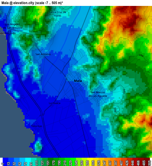
Below is the Elevation map of Mala, which displays elevation range with different colors. Scale of the first map is from -7 to 505 m (-23 to 1657 ft) with average elevation of 110.7 meters (=363 ft) [note 1]
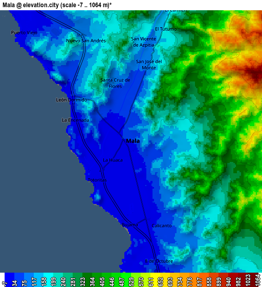
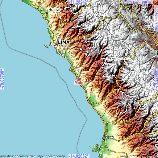
These maps also provides idea of topography and contour of this city, they are displayed at different zoom levels. More info about maps, scale and edge coordinates you can find below images.
| \ | Map #1 | Map #2 | Topo.Map |
| Scale [m] | -7..505 m | -7..1064 m | × |
| Scale [ft] | -23..1657 ft | -23..3491 ft | × |
| Average | 110.7 m = 363 ft | 237.2 m = 778 ft | × |
| Width | 9.53 km = 5.9 mi | 19.07 km = 11.8 mi | 305.1 km = 189.6 mi |
| Height | 9.54 km = 5.9 mi | 19.07 km = 11.8 mi | 305.1 km = 189.6 mi |
| ↑Max Latitude | -12.615179° | -12.572291° | -11.28242° |
| Latitude at center | -12.65806° | -12.65806° | -12.65806° |
| ↓Min Latitude | -12.700934° | -12.7438° | -14.02632° |
| ← Min Longitude | -76.674775° | -76.718721° | -78.03708° |
| Longitude center | -76.63083° | -76.63083° | -76.63083° |
| →Max Longitude | -76.586885° | -76.542939° | -75.22458° |
Nearby cities:
Cities around Mala sort by population:
• Imperial elevation 91 m
53.8 km,  145°
145°
• San Vicente de Cañete 45 m
53.5 km, 150°
• Chilca 11 m
19.1 km,  322°
322°
• Quilmaná 162 m
42.2 km,  140°
140°
• San Bartolo 22 m
34.7 km,  331°
331°
• Quinocay 2430 m
54 km,  53°
53°
• Punta Hermosa 54 m
41.4 km, 330°
• Omas 1618 m
40.9 km,  67°
67°
• Pucusana 33 m
26.7 km, 316°
• Coayllo 260 m
19.7 km,  115°
115°
• Calango 315 m
17.5 km,  33°
33°
• Asia 26 m
15.6 km, 153°
Multilingual:
 En español:
Mala elevación 34 m.
 En France:
Mala élévation 34 m.


Sources and notes:
- [note 1] Map square and city borders are not equal. Map elevation data is calculated only from area inside that square.
- [src 1] Elevation data from geonames database provided with same terms of usage.
- [src 2] The elevation map of Mala is generated using elevation data from NASA's 3 arcsec (90m) resolution SRTM data.
- [src 3] Base (background) map © OpenStreetMap contributors tiles are generated by Geofabrik and OpenTopoMap.
Copyright & License:
This Mala Elevation Map is licensed under CC BY-SA. You may reuse any part from this page, if you give a proper credit by linking to this URL:
 More info on terms of use page.