Tanta elevation
Tanta (Lima region, Provincia de Yauyos), Peru elevation is 4315 meters and Tanta elevation in feet is 14157 ft above sea level [src 1]. Tanta is a seat of a third-order administrative division (feature code) with elevation that is 1994 meters (6542 ft) bigger than average city elevation in Peru.
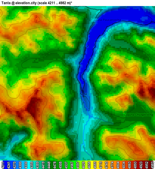
Below is the Elevation map of Tanta, which displays elevation range with different colors. Scale of the first map is from 4211 to 4982 m (13816 to 16345 ft) with average elevation of 4562.8 meters (=14970 ft) [note 1]
These maps also provides idea of topography and contour of this city, they are displayed at different zoom levels. More info about maps, scale and edge coordinates you can find below images.
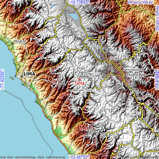
| \ | Map #1 | Topo.Map |
| Scale [m] | 4211..4982 m | × |
| Scale [ft] | 13816..16345 ft | × |
| Average | 4562.8 m = 14970 ft | × |
| Width | 9.55 km = 5.9 mi | 305.7 km = 190 mi |
| Height | 9.55 km = 5.9 mi | 305.8 km = 190 mi |
| ↑Max Latitude | -12.0737° | -10.73833° |
| Latitude at center | -12.11667° | -12.11667° |
| ↓Min Latitude | -12.159633° | -13.48793° |
| ← Min Longitude | -76.060615° | -77.42292° |
| Longitude center | -76.01667° | -76.01667° |
| →Max Longitude | -75.972725° | -74.61042° |
Nearby cities:
Cities around Tanta sort by population:
• Suitucancha elevation 4254 m
37.7 km,  13°
13°
• Mariatana 3548 m
37.5 km,  246°
246°
• Quinocay 2430 m
36.4 km,  220°
220°
• Laraos 3470 m
35.8 km,  135°
135°
• Tomas 3869 m
32.5 km,  114°
114°
• Huampara 2519 m
31.6 km,  214°
214°
• Alis 3289 m
30.8 km,  125°
125°
• Carania 3767 m
30 km,  147°
147°
• Sangallaya 4006 m
27.7 km,  258°
258°
• Vitis 3579 m
25.8 km,  117°
117°
• Huancaya 3570 m
25.6 km, 112°
• Miraflores 3656 m
25.2 km, 133°
Multilingual:
 En español:
Tanta elevación 4315 m.
 En France:
Tanta élévation 4315 m.


Sources and notes:
- [note 1] Map square and city borders are not equal. Map elevation data is calculated only from area inside that square.
- [src 1] Elevation data from geonames database provided with same terms of usage.
- [src 2] The elevation map of Tanta is generated using elevation data from NASA's 3 arcsec (90m) resolution SRTM data.
- [src 3] Base (background) map © OpenStreetMap contributors tiles are generated by Geofabrik and OpenTopoMap.
Copyright & License:
This Tanta Elevation Map is licensed under CC BY-SA. You may reuse any part from this page, if you give a proper credit by linking to this URL:
 More info on terms of use page.