Suitucancha elevation
Suitucancha (Junin, Provincia de Yauli), Peru elevation is 4254 meters and Suitucancha elevation in feet is 13957 ft above sea level [src 1]. Suitucancha is a seat of a third-order administrative division (feature code) with elevation that is 1933 meters (6342 ft) bigger than average city elevation in Peru.
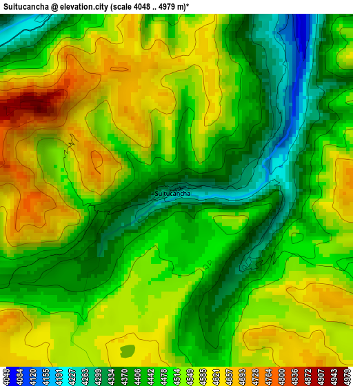
Below is the Elevation map of Suitucancha, which displays elevation range with different colors. Scale of the first map is from 4048 to 4979 m (13281 to 16335 ft) with average elevation of 4499 meters (=14760 ft) [note 1]
These maps also provides idea of topography and contour of this city, they are displayed at different zoom levels. More info about maps, scale and edge coordinates you can find below images.
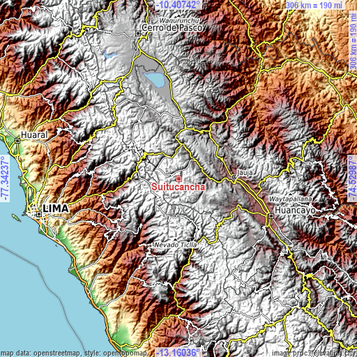
| \ | Map #1 | Topo.Map |
| Scale [m] | 4048..4979 m | × |
| Scale [ft] | 13281..16335 ft | × |
| Average | 4499 m = 14760 ft | × |
| Width | 9.57 km = 5.9 mi | 306.1 km = 190.2 mi |
| Height | 9.57 km = 5.9 mi | 306.1 km = 190.2 mi |
| ↑Max Latitude | -11.744318° | -10.40742° |
| Latitude at center | -11.78734° | -11.78734° |
| ↓Min Latitude | -11.830355° | -13.16036° |
| ← Min Longitude | -75.980065° | -77.34237° |
| Longitude center | -75.93612° | -75.93612° |
| →Max Longitude | -75.892175° | -74.52987° |
Nearby cities:
Cities around Suitucancha sort by population:
• La Oroya elevation 3765 m
30.1 km,  7°
7°
• Morococha 4512 m
30.6 km,  313°
313°
• San Mateo 3159 m
39.8 km,  274°
274°
• Tanta 4315 m
37.7 km,  193°
193°
• Chicla 3697 m
37.3 km,  283°
283°
• Paccha 3754 m
34.9 km,  355°
355°
• Pomacancha 3801 m
34.4 km,  80°
80°
• Llocllapampa 3509 m
34.2 km,  95°
95°
• El Rosario 3552 m
28.5 km,  89°
89°
• Canchayllo 3614 m
24 km, 94°
• Yauli 4123 m
21.3 km, 309°
• Chacapalpa 3745 m
20.5 km,  72°
72°
Multilingual:
 En español:
Suitucancha elevación 4254 m.
 En France:
Suitucancha élévation 4254 m.
 Auf Deutsch:
Suitucancha höhe über dem Meeresspiegel ist 4254 m.

Sources and notes:
- [note 1] Map square and city borders are not equal. Map elevation data is calculated only from area inside that square.
- [src 1] Elevation data from geonames database provided with same terms of usage.
- [src 2] The elevation map of Suitucancha is generated using elevation data from NASA's 3 arcsec (90m) resolution SRTM data.
- [src 3] Base (background) map © OpenStreetMap contributors tiles are generated by Geofabrik and OpenTopoMap.
Copyright & License:
This Suitucancha Elevation Map is licensed under CC BY-SA. You may reuse any part from this page, if you give a proper credit by linking to this URL:
 More info on terms of use page.