Carania elevation
Carania (Lima region, Provincia de Yauyos), Peru elevation is 3767 meters and Carania elevation in feet is 12359 ft above sea level [src 1]. Carania is a seat of a third-order administrative division (feature code) with elevation that is 1446 meters (4744 ft) bigger than average city elevation in Peru.
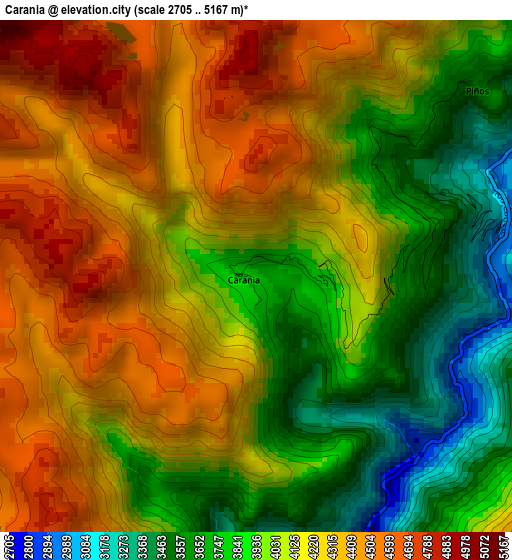
Below is the Elevation map of Carania, which displays elevation range with different colors. Scale of the first map is from 2705 to 5167 m (8875 to 16952 ft) with average elevation of 4091.4 meters (=13423 ft) [note 1]
These maps also provides idea of topography and contour of this city, they are displayed at different zoom levels. More info about maps, scale and edge coordinates you can find below images.
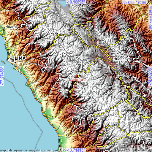
| \ | Map #1 | Topo.Map |
| Scale [m] | 2705..5167 m | × |
| Scale [ft] | 8875..16952 ft | × |
| Average | 4091.4 m = 13423 ft | × |
| Width | 9.55 km = 5.9 mi | 305.5 km = 189.8 mi |
| Height | 9.55 km = 5.9 mi | 305.5 km = 189.8 mi |
| ↑Max Latitude | -12.301237° | -10.96695° |
| Latitude at center | -12.34417° | -12.34417° |
| ↓Min Latitude | -12.387096° | -13.71418° |
| ← Min Longitude | -75.912275° | -77.27458° |
| Longitude center | -75.86833° | -75.86833° |
| →Max Longitude | -75.824385° | -74.46208° |
Nearby cities:
Cities around Carania sort by population:
• Quinocay elevation 2430 m
39.7 km,  266°
266°
• Tauripampa 4525 m
37.9 km,  225°
225°
• Huampara 2519 m
34.2 km, 268°
• Colonia 3366 m
32.2 km,  184°
184°
• Tanta 4315 m
30 km,  327°
327°
• Tomas 3869 m
17.8 km,  48°
48°
• Huancaya 3570 m
17.4 km,  25°
25°
• Vitis 3579 m
15 km, 26°
• Yauyos 2878 m
13.9 km,  202°
202°
• Alis 3289 m
11.5 km, 50°
• Laraos 3470 m
8.9 km,  91°
91°
• Miraflores 3656 m
8.1 km,  14°
14°
Multilingual:
 En español:
Carania elevación 3767 m.
 En France:
Carania élévation 3767 m.
 Auf Deutsch:
Carania höhe über dem Meeresspiegel ist 3767 m.

Sources and notes:
- [note 1] Map square and city borders are not equal. Map elevation data is calculated only from area inside that square.
- [src 1] Elevation data from geonames database provided with same terms of usage.
- [src 2] The elevation map of Carania is generated using elevation data from NASA's 3 arcsec (90m) resolution SRTM data.
- [src 3] Base (background) map © OpenStreetMap contributors tiles are generated by Geofabrik and OpenTopoMap.
Copyright & License:
This Carania Elevation Map is licensed under CC BY-SA. You may reuse any part from this page, if you give a proper credit by linking to this URL:
 More info on terms of use page.