Huampara elevation
Huampara (Lima region, Provincia de Yauyos), Peru elevation is 2519 meters and Huampara elevation in feet is 8264 ft above sea level [src 1]. Huampara is a seat of a third-order administrative division (feature code) with elevation that is 198 meters (650 ft) bigger than average city elevation in Peru.
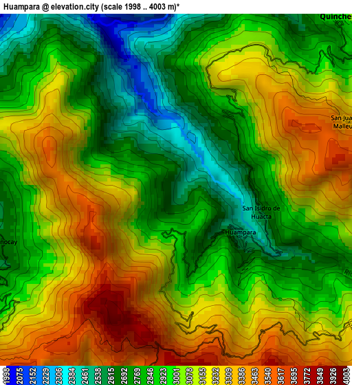
Below is the Elevation map of Huampara, which displays elevation range with different colors. Scale of the first map is from 1998 to 4003 m (6555 to 13133 ft) with average elevation of 3012.9 meters (=9885 ft) [note 1]
These maps also provides idea of topography and contour of this city, they are displayed at different zoom levels. More info about maps, scale and edge coordinates you can find below images.
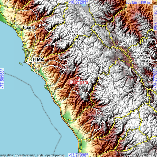
| \ | Map #1 | Topo.Map |
| Scale [m] | 1998..4003 m | × |
| Scale [ft] | 6555..13133 ft | × |
| Average | 3012.9 m = 9885 ft | × |
| Width | 9.55 km = 5.9 mi | 305.5 km = 189.8 mi |
| Height | 9.55 km = 5.9 mi | 305.5 km = 189.8 mi |
| ↑Max Latitude | -12.307068° | -10.97281° |
| Latitude at center | -12.35° | -12.35° |
| ↓Min Latitude | -12.392925° | -13.71998° |
| ← Min Longitude | -76.227275° | -77.58958° |
| Longitude center | -76.18333° | -76.18333° |
| →Max Longitude | -76.139385° | -74.77708° |
Nearby cities:
Cities around Huampara sort by population:
• Vitis elevation 3579 m
43.3 km,  71°
71°
• Laraos 3470 m
43.1 km,  89°
89°
• Miraflores 3656 m
37.2 km,  76°
76°
• Lahuaytambo 3067 m
36.4 km,  319°
319°
• Carania 3767 m
34.2 km, 88°
• Tanta 4315 m
31.6 km,  34°
34°
• Yauyos 2878 m
31.4 km,  112°
112°
• Tauripampa 4525 m
26.9 km,  164°
164°
• Sangallaya 4006 m
22.3 km,  336°
336°
• Omas 1618 m
21.5 km,  210°
210°
• Mariatana 3548 m
19.7 km,  304°
304°
• Quinocay 2430 m
5.7 km,  251°
251°
Multilingual:
 En español:
Huampara elevación 2519 m.
 En France:
Huampara élévation 2519 m.
 Auf Deutsch:
Huampara höhe über dem Meeresspiegel ist 2519 m.

Sources and notes:
- [note 1] Map square and city borders are not equal. Map elevation data is calculated only from area inside that square.
- [src 1] Elevation data from geonames database provided with same terms of usage.
- [src 2] The elevation map of Huampara is generated using elevation data from NASA's 3 arcsec (90m) resolution SRTM data.
- [src 3] Base (background) map © OpenStreetMap contributors tiles are generated by Geofabrik and OpenTopoMap.
Copyright & License:
This Huampara Elevation Map is licensed under CC BY-SA. You may reuse any part from this page, if you give a proper credit by linking to this URL:
 More info on terms of use page.