Isiaka elevation
Isiaka (Ebonyi, Ivo), Nigeria elevation is 75 meters and Isiaka elevation in feet is 246 ft above sea level [src 1]. Isiaka is a seat of a second-order administrative division (feature code) with elevation that is 222 meters (728 ft) smaller than average city elevation in Nigeria.
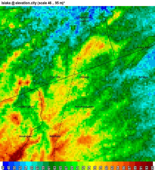
Below is the Elevation map of Isiaka, which displays elevation range with different colors. Scale of the first map is from 46 to 95 m (151 to 312 ft) with average elevation of 66.8 meters (=219 ft) [note 1]
These maps also provides idea of topography and contour of this city, they are displayed at different zoom levels. More info about maps, scale and edge coordinates you can find below images.
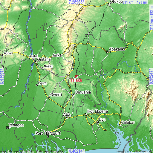
| \ | Map #1 | Topo.Map |
| Scale [m] | 46..95 m | × |
| Scale [ft] | 151..312 ft | × |
| Average | 66.8 m = 219 ft | × |
| Width | 9.72 km = 6 mi | 311.1 km = 193.3 mi |
| Height | 9.72 km = 6 mi | 311.1 km = 193.3 mi |
| ↑Max Latitude | 5.906364° | 7.25965° |
| Latitude at center | 5.86265° | 5.86265° |
| ↓Min Latitude | 5.818933° | 4.46214° |
| ← Min Longitude | 7.502275° | 6.13997° |
| Longitude center | 7.54622° | 7.54622° |
| →Max Longitude | 7.590165° | 8.95247° |
Nearby cities:
Cities around Isiaka sort by population:
• Amaigbo elevation 84 m
33.3 km,  104°
104°
• Okigwe 158 m
22 km,  260°
260°
• Bende 123 m
35.1 km,  164°
164°
• Awgu 133 m
24.6 km,  341°
341°
• Mberubu 82 m
35.7 km,  15°
15°
• Ake-Eze 52 m
15.6 km,  67°
67°
• Isinweke 171 m
34.6 km,  218°
218°
• Nguzu Edda 184 m
32.3 km,  111°
111°
• Obiozara 53 m
32.3 km,  50°
50°
• Nkwoagu Isuochi 319 m
22 km,  310°
310°
• Ndeaboh 83 m
19.2 km,  7°
7°
• Mbalano 223 m
15.1 km,  198°
198°
Multilingual:
 En español:
Isiaka elevación 75 m.
 En France:
Isiaka élévation 75 m.


Sources and notes:
- [note 1] Map square and city borders are not equal. Map elevation data is calculated only from area inside that square.
- [src 1] Elevation data from geonames database provided with same terms of usage.
- [src 2] The elevation map of Isiaka is generated using elevation data from NASA's 3 arcsec (90m) resolution SRTM data.
- [src 3] Base (background) map © OpenStreetMap contributors tiles are generated by Geofabrik and OpenTopoMap.
Copyright & License:
This Isiaka Elevation Map is licensed under CC BY-SA. You may reuse any part from this page, if you give a proper credit by linking to this URL:
 More info on terms of use page.