Nkwoagu Isuochi elevation
Nkwoagu Isuochi (Abia, Umu-Nneochi), Nigeria elevation is 319 meters and Nkwoagu Isuochi elevation in feet is 1047 ft above sea level [src 1]. Nkwoagu Isuochi is a seat of a second-order administrative division (feature code) with elevation that is 22 meters (72 ft) bigger than average city elevation in Nigeria.
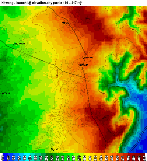
Below is the Elevation map of Nkwoagu Isuochi, which displays elevation range with different colors. Scale of the first map is from 116 to 417 m (381 to 1368 ft) with average elevation of 295.2 meters (=969 ft) [note 1]
These maps also provides idea of topography and contour of this city, they are displayed at different zoom levels. More info about maps, scale and edge coordinates you can find below images.
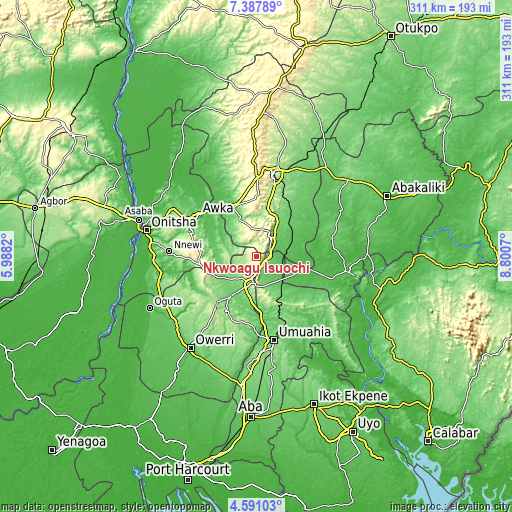
| \ | Map #1 | Topo.Map |
| Scale [m] | 116..417 m | × |
| Scale [ft] | 381..1368 ft | × |
| Average | 295.2 m = 969 ft | × |
| Width | 9.72 km = 6 mi | 311 km = 193.2 mi |
| Height | 9.72 km = 6 mi | 311 km = 193.2 mi |
| ↑Max Latitude | 6.034954° | 7.38789° |
| Latitude at center | 5.99125° | 5.99125° |
| ↓Min Latitude | 5.947543° | 4.59103° |
| ← Min Longitude | 7.350505° | 5.9882° |
| Longitude center | 7.39445° | 7.39445° |
| →Max Longitude | 7.438395° | 8.8007° |
Nearby cities:
Cities around Nkwoagu Isuochi sort by population:
• Okigwe elevation 158 m
18.7 km,  195°
195°
• Awgu 133 m
12.9 km,  45°
45°
• Mberubu 82 m
33 km, 52°
• Ake-Eze 52 m
32.2 km,  104°
104°
• Aguata 307 m
34 km,  274°
274°
• Oji River 74 m
32.4 km,  334°
334°
• Mbalano 223 m
31 km,  157°
157°
• Okwe 128 m
30.8 km,  219°
219°
• Isiaka 75 m
22 km,  130°
130°
• Ajalli 140 m
21.4 km,  286°
286°
• Ndeaboh 83 m
19.8 km,  76°
76°
• Umunze 189 m
17.7 km,  261°
261°
Multilingual:
 En español:
Nkwoagu Isuochi elevación 319 m.
 En France:
Nkwoagu Isuochi élévation 319 m.
 Auf Deutsch:
Nkwoagu Isuochi höhe über dem Meeresspiegel ist 319 m.

Sources and notes:
- [note 1] Map square and city borders are not equal. Map elevation data is calculated only from area inside that square.
- [src 1] Elevation data from geonames database provided with same terms of usage.
- [src 2] The elevation map of Nkwoagu Isuochi is generated using elevation data from NASA's 3 arcsec (90m) resolution SRTM data.
- [src 3] Base (background) map © OpenStreetMap contributors tiles are generated by Geofabrik and OpenTopoMap.
Copyright & License:
This Nkwoagu Isuochi Elevation Map is licensed under CC BY-SA. You may reuse any part from this page, if you give a proper credit by linking to this URL:
 More info on terms of use page.