Amaigbo elevation
Amaigbo (Abia), Nigeria elevation is 84 meters and Amaigbo elevation in feet is 276 ft above sea level [src 1]. Amaigbo is a populated place (feature code) with elevation that is 213 meters (699 ft) smaller than average city elevation in Nigeria.
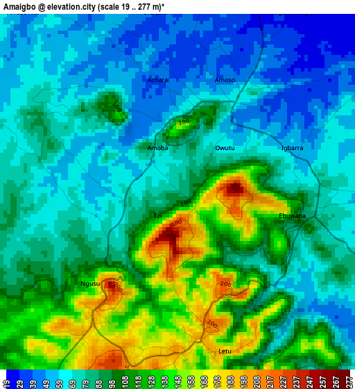
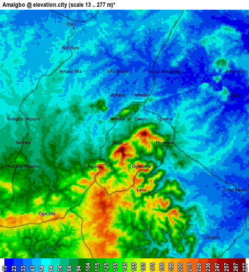
Below is the Elevation map of Amaigbo, which displays elevation range with different colors. Scale of the first map is from 19 to 277 m (62 to 909 ft) with average elevation of 91.5 meters (=300 ft) [note 1]
These maps also provides idea of topography and contour of this city, they are displayed at different zoom levels. More info about maps, scale and edge coordinates you can find below images.
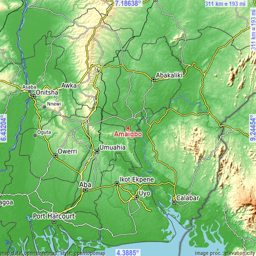
| \ | Map #1 | Map #2 | Topo.Map |
| Scale [m] | 19..277 m | 13..277 m | × |
| Scale [ft] | 62..909 ft | 43..909 ft | × |
| Average | 91.5 m = 300 ft | 79.5 m = 261 ft | × |
| Width | 9.72 km = 6 mi | 19.45 km = 12.1 mi | 311.1 km = 193.3 mi |
| Height | 9.72 km = 6 mi | 19.45 km = 12.1 mi | 311.1 km = 193.3 mi |
| ↑Max Latitude | 5.832889° | 5.876606° | 7.18638° |
| Latitude at center | 5.78917° | 5.78917° | 5.78917° |
| ↓Min Latitude | 5.745447° | 5.701721° | 4.3885° |
| ← Min Longitude | 7.794345° | 7.750399° | 6.43204° |
| Longitude center | 7.83829° | 7.83829° | 7.83829° |
| →Max Longitude | 7.882235° | 7.926181° | 9.24454° |
Nearby cities:
Cities around Amaigbo sort by population:
• Ugep elevation 101 m
26.9 km,  85°
85°
• Bende 123 m
34.2 km,  221°
221°
• Ohafia-Ifigh 124 m
19.6 km,  188°
188°
• Afikpo 92 m
15.7 km,  43°
43°
• Ake-Eze 52 m
22.9 km,  308°
308°
• Mbalano 223 m
37.7 km,  260°
260°
• Akpet Central 113 m
34.6 km,  122°
122°
• Isiaka 75 m
33.3 km,  284°
284°
• Obiozara 53 m
29.5 km,  345°
345°
• Itigidi 64 m
23.3 km,  60°
60°
• Ebem Ohafia 172 m
17.6 km,  182°
182°
• Nguzu Edda 184 m
4.4 km,  211°
211°
Multilingual:
 En español:
Amaigbo elevación 84 m.
 En France:
Amaigbo élévation 84 m.


Sources and notes:
- [note 1] Map square and city borders are not equal. Map elevation data is calculated only from area inside that square.
- [src 1] Elevation data from geonames database provided with same terms of usage.
- [src 2] The elevation map of Amaigbo is generated using elevation data from NASA's 3 arcsec (90m) resolution SRTM data.
- [src 3] Base (background) map © OpenStreetMap contributors tiles are generated by Geofabrik and OpenTopoMap.
Copyright & License:
This Amaigbo Elevation Map is licensed under CC BY-SA. You may reuse any part from this page, if you give a proper credit by linking to this URL:
 More info on terms of use page.