Ugep elevation
Ugep (Cross River, Yakurr), Nigeria elevation is 101 meters and Ugep elevation in feet is 331 ft above sea level [src 1]. Ugep is a seat of a second-order administrative division (feature code) with elevation that is 196 meters (643 ft) smaller than average city elevation in Nigeria.
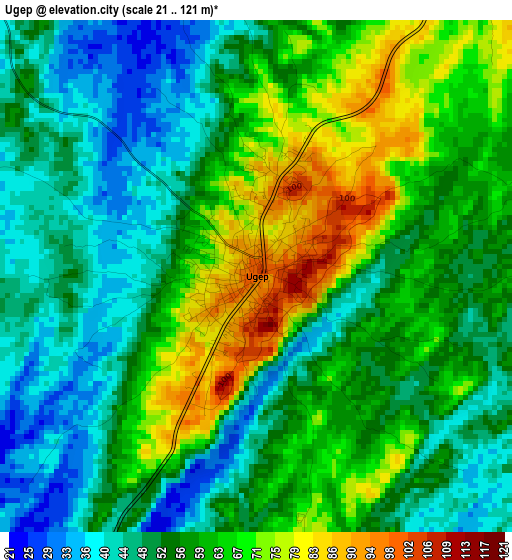
Below is the Elevation map of Ugep, which displays elevation range with different colors. Scale of the first map is from 21 to 121 m (69 to 397 ft) with average elevation of 56.8 meters (=186 ft) [note 1]
These maps also provides idea of topography and contour of this city, they are displayed at different zoom levels. More info about maps, scale and edge coordinates you can find below images.
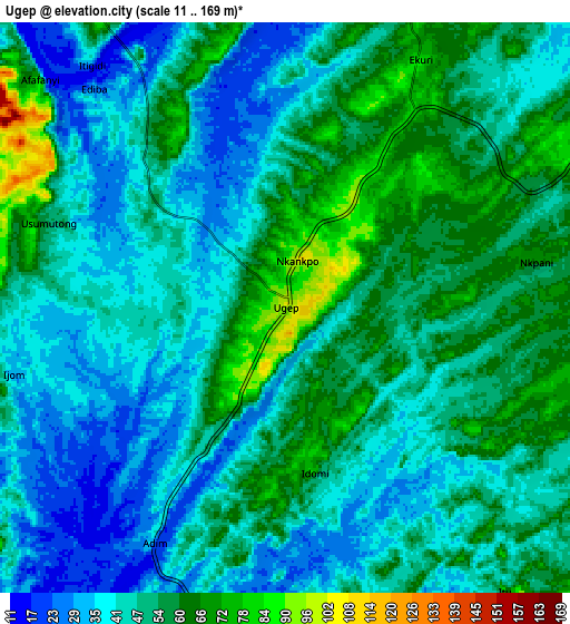
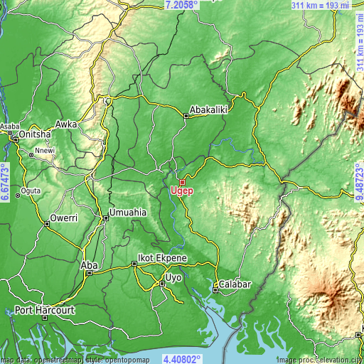
| \ | Map #1 | Map #2 | Topo.Map |
| Scale [m] | 21..121 m | 11..169 m | × |
| Scale [ft] | 69..397 ft | 36..554 ft | × |
| Average | 56.8 m = 186 ft | 49 m = 161 ft | × |
| Width | 9.72 km = 6 mi | 19.44 km = 12.1 mi | 311.1 km = 193.3 mi |
| Height | 9.72 km = 6 mi | 19.44 km = 12.1 mi | 311.1 km = 193.3 mi |
| ↑Max Latitude | 5.852368° | 5.896083° | 7.2058° |
| Latitude at center | 5.80865° | 5.80865° | 5.80865° |
| ↓Min Latitude | 5.764929° | 5.721204° | 4.40802° |
| ← Min Longitude | 8.037035° | 7.993089° | 6.67473° |
| Longitude center | 8.08098° | 8.08098° | 8.08098° |
| →Max Longitude | 8.124925° | 8.168871° | 9.48723° |
Nearby cities:
Cities around Ugep sort by population:
• Amaigbo elevation 84 m
26.9 km,  265°
265°
• Ohafia-Ifigh 124 m
36.8 km,  234°
234°
• Afikpo 92 m
18.6 km,  300°
300°
• Obubra 91 m
40.8 km,  43°
43°
• Ake-Eze 52 m
46.4 km,  285°
285°
• Obiozara 53 m
43.1 km,  307°
307°
• Onueke 91 m
38.9 km,  352°
352°
• Ebem Ohafia 172 m
34 km, 234°
• Onuebonyi Echara 56 m
32.8 km,  13°
13°
• Nguzu Edda 184 m
29.8 km,  258°
258°
• Akpet Central 113 m
21 km,  173°
173°
• Itigidi 64 m
11.3 km,  324°
324°
Multilingual:
 En español:
Ugep elevación 101 m.
 En France:
Ugep élévation 101 m.


Sources and notes:
- [note 1] Map square and city borders are not equal. Map elevation data is calculated only from area inside that square.
- [src 1] Elevation data from geonames database provided with same terms of usage.
- [src 2] The elevation map of Ugep is generated using elevation data from NASA's 3 arcsec (90m) resolution SRTM data.
- [src 3] Base (background) map © OpenStreetMap contributors tiles are generated by Geofabrik and OpenTopoMap.
Copyright & License:
This Ugep Elevation Map is licensed under CC BY-SA. You may reuse any part from this page, if you give a proper credit by linking to this URL:
 More info on terms of use page.