Ifaki elevation
Ifaki (Ekiti, Ido-Osi), Nigeria elevation is 571 meters and Ifaki elevation in feet is 1873 ft above sea level [src 1]. Ifaki is a populated place (feature code) with elevation that is 274 meters (899 ft) bigger than average city elevation in Nigeria.
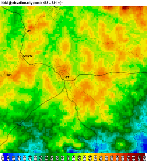
Below is the Elevation map of Ifaki, which displays elevation range with different colors. Scale of the first map is from 468 to 631 m (1535 to 2070 ft) with average elevation of 551.3 meters (=1809 ft) [note 1]
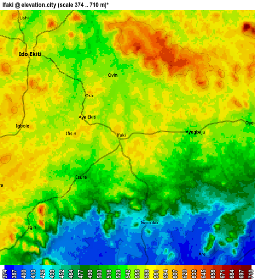
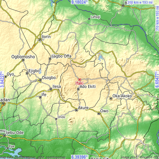
These maps also provides idea of topography and contour of this city, they are displayed at different zoom levels. More info about maps, scale and edge coordinates you can find below images.
| \ | Map #1 | Map #2 | Topo.Map |
| Scale [m] | 468..631 m | 374..710 m | × |
| Scale [ft] | 1535..2070 ft | 1227..2329 ft | × |
| Average | 551.3 m = 1809 ft | 533.6 m = 1751 ft | × |
| Width | 9.68 km = 6 mi | 19.36 km = 12 mi | 309.8 km = 192.5 mi |
| Height | 9.68 km = 6 mi | 19.36 km = 12 mi | 309.8 km = 192.5 mi |
| ↑Max Latitude | 7.832958° | 7.876491° | 9.18024° |
| Latitude at center | 7.78942° | 7.78942° | 7.78942° |
| ↓Min Latitude | 7.745878° | 7.702331° | 6.39396° |
| ← Min Longitude | 5.204575° | 5.160629° | 3.84227° |
| Longitude center | 5.24852° | 5.24852° | 5.24852° |
| →Max Longitude | 5.292465° | 5.336411° | 6.65477° |
Nearby cities:
Cities around Ifaki sort by population:
• Ado-Ekiti elevation 439 m
18.7 km,  189°
189°
• Ijero-Ekiti 491 m
20.2 km,  278°
278°
• Igede-Ekiti 576 m
19 km,  225°
225°
• Ipoti 593 m
21.1 km,  296°
296°
• Aramoko-Ekiti 458 m
24.8 km,  247°
247°
• Araromi-Opin 521 m
30.7 km,  1°
1°
• Ikole-Ekiti 570 m
28.7 km,  89°
89°
• Ilawe-Ekiti 426 m
26.5 km,  216°
216°
• Otun-Ekiti 535 m
26.1 km,  328°
328°
• Iye-Ekiti 564 m
18.4 km,  354°
354°
• Ido-Ekiti 569 m
9.6 km,  311°
311°
• Oye-Ekiti 536 m
9.3 km,  82°
82°
Multilingual:
 En español:
Ifaki elevación 571 m.
 En France:
Ifaki élévation 571 m.


Sources and notes:
- [note 1] Map square and city borders are not equal. Map elevation data is calculated only from area inside that square.
- [src 1] Elevation data from geonames database provided with same terms of usage.
- [src 2] The elevation map of Ifaki is generated using elevation data from NASA's 3 arcsec (90m) resolution SRTM data.
- [src 3] Base (background) map © OpenStreetMap contributors tiles are generated by Geofabrik and OpenTopoMap.
Copyright & License:
This Ifaki Elevation Map is licensed under CC BY-SA. You may reuse any part from this page, if you give a proper credit by linking to this URL:
 More info on terms of use page.