Iguobazuwa elevation
Iguobazuwa (Edo, Ovia South-West), Nigeria elevation is 128 meters and Iguobazuwa elevation in feet is 420 ft above sea level [src 1]. Iguobazuwa is a seat of a second-order administrative division (feature code) with elevation that is 169 meters (554 ft) smaller than average city elevation in Nigeria.
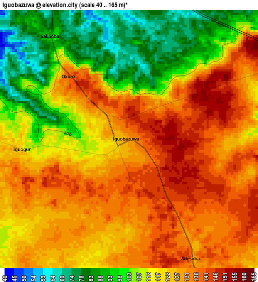
Below is the Elevation map of Iguobazuwa, which displays elevation range with different colors. Scale of the first map is from 40 to 165 m (131 to 541 ft) with average elevation of 118.6 meters (=389 ft) [note 1]
These maps also provides idea of topography and contour of this city, they are displayed at different zoom levels. More info about maps, scale and edge coordinates you can find below images.
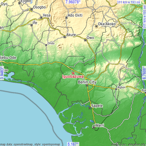
| \ | Map #1 | Topo.Map |
| Scale [m] | 40..165 m | × |
| Scale [ft] | 131..541 ft | × |
| Average | 118.6 m = 389 ft | × |
| Width | 9.71 km = 6 mi | 310.6 km = 193 mi |
| Height | 9.71 km = 6 mi | 310.7 km = 193.1 mi |
| ↑Max Latitude | 6.609505° | 7.96078° |
| Latitude at center | 6.56585° | 6.56585° |
| ↓Min Latitude | 6.522191° | 5.167° |
| ← Min Longitude | 5.310605° | 3.9483° |
| Longitude center | 5.35455° | 5.35455° |
| →Max Longitude | 5.398495° | 6.7608° |
Nearby cities:
Cities around Iguobazuwa sort by population:
• Benin City elevation 88 m
39.2 km,  130°
130°
• Ore 76 m
56.6 km,  290°
290°
• Agbabu 12 m
57.5 km,  272°
272°
• Siluko 51 m
21.7 km,  261°
261°
• Ifon 184 m
61.5 km,  48°
48°
• Igbokoda 7 m
65.3 km,  248°
248°
• Koko 14 m
63.8 km,  169°
169°
• Igbekebo 15 m
59.2 km, 246°
• Ode-Irele 41 m
54.1 km, 261°
• Idogbo 66 m
51.6 km, 129°
• Uselu 110 m
34.7 km, 125°
• Okada 74 m
19.3 km,  13°
13°
Multilingual:
 En español:
Iguobazuwa elevación 128 m.
 En France:
Iguobazuwa élévation 128 m.
 Auf Deutsch:
Iguobazuwa höhe über dem Meeresspiegel ist 128 m.

Sources and notes:
- [note 1] Map square and city borders are not equal. Map elevation data is calculated only from area inside that square.
- [src 1] Elevation data from geonames database provided with same terms of usage.
- [src 2] The elevation map of Iguobazuwa is generated using elevation data from NASA's 3 arcsec (90m) resolution SRTM data.
- [src 3] Base (background) map © OpenStreetMap contributors tiles are generated by Geofabrik and OpenTopoMap.
Copyright & License:
This Iguobazuwa Elevation Map is licensed under CC BY-SA. You may reuse any part from this page, if you give a proper credit by linking to this URL:
 More info on terms of use page.